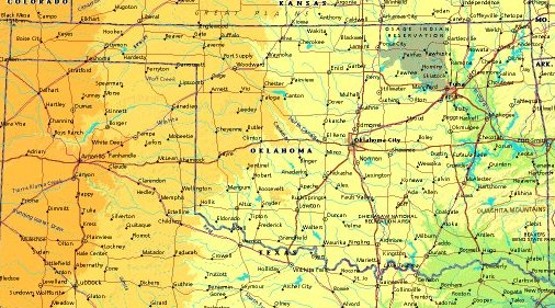
 | UNITED STATES OF AMERICA : OKLAHOMA
|
| General useful information |
| Note: some data are of constant value, while other are due to changes, fluctuations etc. |
| State and population |
| capital: Oklahoma City // state code ISO: OK ; FIPS: US40 |
| surface: 177886 sq.km = 68681 sq.mi // rank in USA: 19 // location: West South Central |
| climate: temeprate; southern humid belt merging with colder northern continental; E humid, W dry |
| entered USA as 46th state on: 1907-11-16 |
| administrative division: 77 counties |
| total population according to the census of 2000: 3,450,654 |
| population density 2000: 19 per sq.km = 50 per sq.mi // net growth 1999-2000: 9,7% |
| main ethnic groups: white 76,2%; black 7,6%; Asian 1,4%; Native American/Nat. AK 7,9%; other 7% |
| Economy and infrastructure |
| chief crops: wheat, cotton, hay, peanuts, grain sorghum, soybeans, corn, pecans |
| livestock (million): cattle: 5,1 / pigs: 2,3 / poultry: 5,3 ; broilers 216,4 / sheep: 0,055 |
| timber/lumber: pine, oak, hickory |
| chief industries: manufacturing, mineral & energy exploration & production, agriculture, services |
| chief industrial products: nonelectrical machinery, transportation equipment, food products |
| chief mining products: crushed stone, portland cement, sand & gravel, helium |
| Some physical landmarks |
| highest point in the state: Black Mesa 1516 m = 4973 ft |
| other mountains: a nameless mountain in the SW corner (W of Felt) of the NW panhandle of 1433 m |
| lowest point in the state: ca 110 m in the SE corner |
| lakes: possibly no natural lakes |
| artificial lakes: Eufaula Lake, Robert S. Kerr Res., L. Hudson, L. O' The Cherokees, L. Texoma, Oologah L. |
| rivers: Arkansas, Red River, Canadian, Washita, Neosho |
| others: islands: none // deserts: |
| Additional remarks, especially on the statistical information |
| other important features: |
| nick name(s): Sooner State |
| motto: Labor Omnia Vincit (Labor conquers all things) |
| song: Oklahoma! |
| flower: Mistletoe // bird: Scissor-tailed flycatcher // tree: Redbud |
| primary sources: |
| World almanac and book of facts; National Geographic Atlas of the World; maps: WN world @tlas |
 Back to the page containing general information of the whole country
 To the page containing the population growth statistics of the whole country
 to the secondary administrative division of the state
 To the page containing historical population statistics of some important towns of the state
 To the page containing urban historical population statistics of the whole country
 Back to the homepage of this website: POPULATION STATISTICS
File created on 2003.03.04 by Jan Lahmeyer
© "populstat" site: Jan Lahmeyer