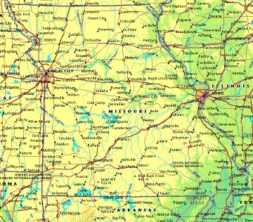
 | UNITED STATES OF AMERICA : MISSOURI
|
| General useful information |
| Note: some data are of constant value, while other are due to changes, fluctuations etc. |
| State and population |
| capital: Jefferson City // state code ISO: MO ; FIPS: US29 |
| surface: 178451 sq.km = 68909 sq.mi // rank in USA: 18 // location: West North Central |
| climate: continental, suspectibel to cold Canadian air, moist, warm gulf air, and drier SW air |
| entered USA as 24th state on: 1821-08-10 |
| administrative division: 114 counties |
| total population according to the census of 2000: 5,595,211 |
| population density 2000: 31 per sq.km = 81 per sq.mi // net growth 1999-2000: 9,3% |
| main ethnic groups: white 84,9%; black 11,2%; Asian 1,1%; other 3% |
| Economy and infrastructure |
| chief crops: soybeans, corn, wheat, hay |
| livestock (million): cattle: 4,3 / pigs: 2,9 / poultry: 8,2; broilers 249,7 / sheep: 0,073 |
| timber/lumber: oak, hickory |
| chief industries: agriculture, manufacturing, aerospace, tourism |
| chief industrial products: transportation equipment, food & related products, electric & electronic equipment |
| chief mining products: crushed stone, lead, portland cement, lime, zinc |
| Some physical landmarks |
| highest point in the state: Taum Sauk Mt. 540 m = 1772 ft |
| other mountains: there are some more but without names on the maps available |
| lowest point in the state: ca 80 m in the SE corner |
| lakes: if there are any natural lakes, they are hardly recognisable on maps |
| artificial lakes: Lake of the Ozarks, Table Rock L., Bull Shoals L., Clearwater L., L. Wappapello, Stockton L. |
| rivers: Mississippi, Missouri |
| others: islands: none // deserts: none |
| Additional remarks, especially on the statistical information |
| other important features: |
| nick name(s): Show Me State |
| motto: Salus Populi Suprema Lex Esto (The welfare of the people shall be the supreme law) |
| song: Missouri Waltz |
| flower: Hawthorn // bird: Bluebird // tree: Dogwood |
| primary sources: |
| World almanac and book of facts; National Geographic Atlas of the World; maps: WN world @tlas |
 Back to the page containing general information of the whole country
 To the page containing the population growth statistics of the whole country
 to the secondary administrative division of the state
 To the page containing historical population statistics of some important towns of the state
 To the page containing urban historical population statistics of the whole country
 Back to the homepage of this website: POPULATION STATISTICS
File created on 2003.03.02 by Jan Lahmeyer
© "populstat" site: Jan Lahmeyer