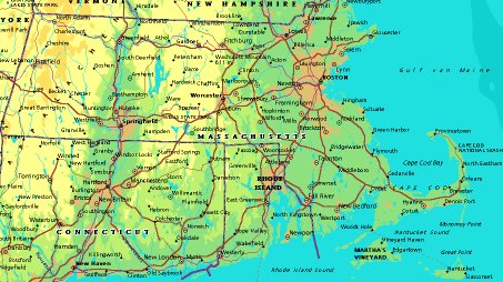
 | UNITED STATES OF AMERICA : MASSACHUSETTS
|
| General useful information |
| Note: some data are of constant value, while other are due to changes, fluctuations etc. |
| State and population |
| capital: Boston // state code ISO: MA ; FIPS: US25 |
| surface: 20301 sq.km = 7840 sq.mi // rank in USA: 44 // location: New England |
| climate: temperate, with colder and drier climate in western region |
| entered USA as 6th state ratifying the Constitution on: 1788-02-06 |
| administrative division: 14 counties |
| total population according to the census of 2000: 6,349,097 |
| population density 2000: 313 per sq.km = 810 per sq.mi // net growth 1999-2000: 5,5% |
| main ethnic groups: white 84,5%; black 5,4%, Asian 3,8%; other 9% |
| Economy and infrastructure |
| chief crops: cranberries, greenhouse, nursery, vegetables |
| livestock (1000s): cattle: 50 / pigs: 20 / poultry: 357 |
| timber/lumber: white pine, oak, other hardwoods |
| chief industries: services, trade, manufacturing |
| chief industrial products: electric & electronic equipment, instruments, industrial machinery & equipment |
| chief mining products: crushed stone, sand & gravel, dimension stone, lime, clays |
| Some physical landmarks |
| highest point in the state: Mt. Greylock 1064 m = 3491 ft |
| other mountains: Mt. Everett 793 |
| lowest point in the state: sea level |
| lakes: Lake Onota, Pontoosuc Lake, Long Pond |
| artificial lakes: Quabbin Res., Wachusett Res., Sudbury Res., Cobble Mt. Res., Knightville Res., Otis Res. |
| rivers: Connecticut, Merrimack, Charles, Housatonic, Blackstone, Taunton, Nashua, Concord |
| others: islands: Martha's Vineyard, Nantucket Island, Elizabeth Islands // deserts: none |
| Additional remarks, especially on the statistical information |
| other important features: |
| nick name(s): Bay State, Old Colony |
| motto: Ense Petit Placidam Sub Libertate Quietem (By the sword we seek peace, but peace only under liberty) |
| song: All Hail to Massachusetts |
| flower: Mayflower // bird: Chickadee // tree: American elm |
| primary sources: |
| World almanac and book of facts; National Geographic Atlas of the World; maps: WN world @tlas |
 Back to the page containing general information of the whole country
 To the page containing the population growth statistics of the whole country
 to the secondary administrative division of the state
 To the page containing historical population statistics of some important towns of the state
 To the page containing urban historical population statistics of the whole country
 Back to the homepage of this website: POPULATION STATISTICS
File created on 2003.02.28 by Jan Lahmeyer
© "populstat" site: Jan Lahmeyer