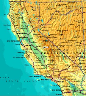
 | UNITED STATES OF AMERICA : CALIFORNIA
|
| General useful information |
| Note: some data are of constant value, while other are due to changes, fluctuations etc. |
| State and population |
| capital: Sacramento // state code ISO: CA ; FIPS: US06 |
| surface: 403972 sq.km = 155978 sq.mi // rank in USA: 3 // location: Western Coast |
| climate: moderate temperatures along the coast; extremes in the interior |
| entered USA as 31st state on: 1850-09-09 |
| administrative division: 58 counties |
| total population according to the census of 2000: 33,871,648 |
| population density 2000: 84 per sq.km = 217 per sq.mi // net growth 1999-2000: 14% |
| main ethnic groups: white 60%; black 7%; Asian 11%; Native American/Nat. AK: 1%; other 22% |
| Economy and infrastructure |
| chief crops/farm products: milk & cream, grapes, cotton, flowers, oranges, rice, nursery products |
| livestock (million): cattle: 5,2 / pigs: 0,15 / poultry: 30 / sheep: 0,84 |
| timber/lumber: fir, pine, redwood, oak |
| chief industries: agriculture, tourism, apparel, electronics, telecommunications, entertainment |
| chief indust. products: electronic & electrical equip., computers, industrial machinery, transportation |
| chief mining products: portland cement, sand & gravel, boron, crushed stone, gold |
| Some physical landmarks |
| highest point in the state: Mt. Whitney 4418 m = 14494 ft |
| other mountains: Mt. Williamson 4381 m, Mt. Darwin 4341 m, Mt. Shasta 4317 m |
| lowest point in the state: -86 m (Death Valley) |
| lakes: Salton Sea, Lake Tahoe, Goose L., Clear L., Mono L., Honey L., Eagle L., L. Berryessa |
| artificial lakes: Shasta L., Clear Engle L., L. Almanor, San Luis Res., L. Oroville, Clear Lake Res. |
| rivers: Sacramento, San Joaquin |
| islands: Santa Catalina, Santa Rosa, Santa Cruz // deserts: Mojave Desert, Sonoran Desert |
| Additional remarks, especially on the statistical information |
| other important features: |
| nick name(s): Golden State |
| motto: Eureka (I have found it) |
| song: I love you, California |
| flower: Golden poppy // bird: California valley quail // tree: California redwood |
| primary sources: |
| World almanac and book of facts; National Geographic Atlas of the World; maps: WN world @tlas |
 Back to the page containing general information of the whole country
 To the page containing the population growth statistics of the whole country
 to the secondary administrative division of the state
 To the page containing historical population statistics of some important towns of the state
 To the page containing urban historical population statistics of the whole country
 Back to the homepage of this website: POPULATION STATISTICS
File created on 2003.02.14 by Jan Lahmeyer
© "populstat" site: Jan Lahmeyer