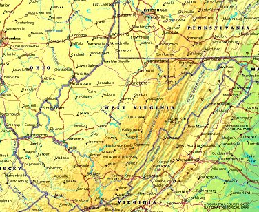
 | UNITED STATES OF AMERICA : WEST VIRGINIA
|
| General useful information |
| Note: some data are of constant value, while other are due to changes, fluctuations etc. |
| State and population |
| capital: Charleston // state code ISO: WV ; FIPS: US54 |
| surface: 62387 sq.km = 24090 sq.mi // rank in USA: 41 // location: South Atlantic |
| climate: himid continental climate, except for marine modification in the lower panhandle |
| entered USA as 35th state on: 1863-06-20 |
| administrative division: 55 counties |
| total population according to the census of 2000: 1,808,344 |
| population density 2000: 29 per sq.km = 75 per sq.mi // net growth 1999-2000: 0,8% |
| main ethnic groups: white 95,0%; black 3,2%; Asian 0,5%; other 1,3% |
| Economy and infrastructure |
| chief crops: apples, peaches, hay, tobacco, corn, wheat, oats |
| livestock (million): cattle: 0,4 / pigs: 0,01 / poultry: 1,9; broilers 89,5 / sheep: 0,035 |
| timber/lumber: oak, yellow poplar, hickory, walnut, cherry |
| chief industries: manufacturing, services, mining, tourism |
| chief industrial products: machinery, plastic & hardwood products, fabricated metals, chemicals |
| chief mining products: crushed stone, portland cement, sand & gravel, lime, salt |
| Some physical landmarks |
| highest point in the state: Spruce Knob 1482 m = 4863 ft |
| other mountains: summit NNW of Cass 1476, Yew Mts. 1436, Briery Knob 1377, Grassy Knob 1333 |
| lowest point in the state: ca 80 m in the NE |
| lakes: hardly any natural lakes of importance |
| artificial lakes: Tygart Lake, Bluestone Lake, Sutton Lake, Summersville Lake, Cheat Lake |
| rivers: Ohio, Potomac, Kanawah, Greenbrier, Guyandotte, Tug Fork, Monongahela |
| others: islands: none // deserts: none |
| Additional remarks, especially on the statistical information |
| other important features: |
| nick name(s): Mountain State |
| motto: Montani Semper Liberi (Mountaineers are always free) |
| songs: The West Virginia Hills; This Is My West Virginia; West Virginia, My Home Sweet Home |
| flower: Big rhododendron // bird: Cardinal // tree: Sugar maple |
| primary sources: |
| World almanac and book of facts; National Geographic Atlas of the World; maps: WN world @tlas |
 Back to the page containing general information of the whole country
 To the page containing the population growth statistics of the whole country
 to the secondary administrative division of the state
 To the page containing historical population statistics of some important towns of the state
 To the page containing urban historical population statistics of the whole country
 Back to the homepage of this website: POPULATION STATISTICS
File created on 2003.03.06 by Jan Lahmeyer
© "populstat" site: Jan Lahmeyer