All countries of the world listed from A-Z:

or choose from the countries per continent below:


 |  |  |  |  |  |
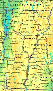 | UNITED STATES OF AMERICA : VERMONT
|
| General useful information |
| Note: some data are of constant value, while other are due to changes, fluctuations etc. |
| State and population |
| capital: Montpelier // state code ISO: VT ; FIPS: US50 |
| surface: 23956 sq.km = 9250 sq.mi // rank in USA: 43 // location: northern New England |
| climate: temperate, with considerable temperature extremes; heavy snowfall in mountains |
| entered USA as 14th state on: 1791-03-04 |
| administrative division: 14 counties |
| total population according to the census of 2000: 608,827 |
| population density 2000: 25 per sq.km = 66 per sq.mi // net growth 1999-2000: 8,2% |
| main ethnic groups: white 96,8%; black 0,5%; Asian 0,9%; other 1,8% |
| Economy and infrastructure |
| chief crops: dairy products, apples, maple syrup, greenhouse & nursery, vegetables, small fruits |
| livestock (1000s): cattle: 295 / pigs: 3 / poultry: 246 (excl. broilers) |
| timber/lumber: pine, spruce, fir, hemlock |
| chief industries: manufacturing, tourism, agriculture, trade, finance, insurance, real estate, government |
| chief industrial products: machine tools, furniture, scales, books, computer components, speciality foods |
| chief mining products: crushed & dimension stone, sand & gravel, talc & pyrophillite, gemstones |
| Some physical landmarks |
| highest point in the state: Mt. Mansfield 1339 m = 4393 ft |
| other mountains: Camels Hump 1224, Stratton Mt. 1200, Jay Pk 1177 |
| lowest point in the state: ca 61 m (level / border of Lake Champlain) |
| lakes: Lake Champlain, Lake Bomoseen, Lake Dunmore, Lake Memphremagog, Lake Carmi, Lake Hortonia |
| artificial lakes: Harriman Res., Somerset Res., Chittenden Res., Waterbury Res., Green River Res. |
| rivers: Connecticut and its upper tributaries; Otter, Winooski, Lamoille, Missisquoi |
| others: islands: none // deserts: none |
| Additional remarks, especially on the statistical information |
| other important features: |
| nick name(s): Green Mountain State |
| motto: Freedom and unity |
| song: These Green Mountains |
| flower: Red clover // bird: Hermit thrush // tree: Sugar maple |
| primary sources: |
| World almanac and book of facts; National Geographic Atlas of the World; maps: WN world @tlas |
 Back to the page containing general information of the whole country
 To the page containing the population growth statistics of the whole country
 to the secondary administrative division of the state
To the page containing historical population statistics of some important towns of the state
To the page containing urban historical population statistics of the whole country
 Back to the homepage of this website: POPULATION STATISTICS
File created on 2003.03.06 by Jan Lahmeyer
© "populstat" site: Jan Lahmeyer