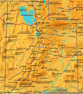
 | UNITED STATES OF AMERICA : UTAH
|
| General useful information |
| Note: some data are of constant value, while other are due to changes, fluctuations etc. |
| State and population |
| capital: Salt Lake City // state code ISO: UT ; FIPS: US49 |
| surface: 212816 sq.km = 82170 sq.mi // rank in USA: 12 // location: West Middle Rocky Mountain |
| climate: arid, ranging from warm desert in SW to alpine in NE |
| entered USA as 45th state on: 1896-01-04 |
| administrative division: 29 counties |
| total population according to the census of 2000: 2,233,169 |
| population density 2000: 10 per sq.km = 27 per sq.mi // net growth 1999-2000: 29,6% |
| main ethnic groups: white 89,2%; black 0,8%; Asian 1,7%; Native American/Nat. AK 1,3%; other 7% |
| Economy and infrastructure |
| chief crops: hay, corn, wheat, barley, apples, potatoes, cherries, onions, peaches, pears |
| livestock (million): cattle: 0,91 / pigs: 0,55 / poultry: 3,8 (excl. broilers) / sheep: 0,39 |
| timber/lumber: aspen, spruce, pine |
| chief industries: services, trade, manufacturing, governement, transportation utilities |
| chief industrial products: medical instruments, electronic components, food products, fabricated metals |
| chief mining products: copper, gold, magnesium metal, portland cement, sand & gravel |
| Some physical landmarks |
| highest point in the state: Kings Pk 4123 m = 13528 ft |
| other mountains: Gilbert Pk 4097, Tokewanna Pk 4013 |
| lowest point in the state: 1128 m (level of Lake Powell) |
| lakes: Great Salt Lake, Utah Lake, Bear Lake, Little Salt Lake, Lake Sevier, North Lake |
| artificial lakes: Lake Powell, Sevier Bridge Res., Flaming Gorge Res. |
| rivers: Colorado, Green, Sevier, Bear, Weber, San Juan, San Rafael |
| others: islands: none // deserts: Great Salt Desert |
| Additional remarks, especially on the statistical information |
| other important features: |
| nick name(s): Beehive State |
| motto: Industry |
| song: Utah, We Love Thee |
| flower: Sego lily // bird: Seagull // tree: Blue spruce |
| primary sources: |
| World almanac and book of facts; National Geographic Atlas of the World; maps: WN world @tlas |
 Back to the page containing general information of the whole country
 To the page containing the population growth statistics of the whole country
 to the secondary administrative division of the state
 To the page containing historical population statistics of some important towns of the state
 To the page containing urban historical population statistics of the whole country
 Back to the homepage of this website: POPULATION STATISTICS
File created on 2003.03.05 by Jan Lahmeyer
© "populstat" site: Jan Lahmeyer