All countries of the world listed from A-Z:

or choose from the countries per continent below:


 |  |  |  |  |  |
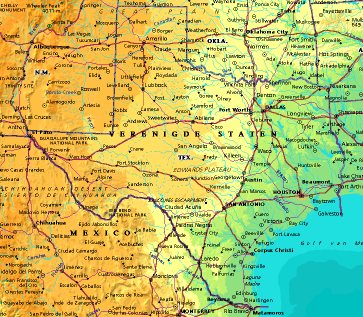 | UNITED STATES OF AMERICA : TEXAS
|
| General useful information |
| Note: some data are of constant value, while other are due to changes, fluctuations etc. |
| State and population |
| capital: Austin // state code ISO: TX ; FIPS: US48 |
| surface: 678371 sq.km = 261925 sq.mi // rank in USA: 2 // location: South Central West |
| climate: extremely varied; driest region is the Trans-Pecos, wettest is the NE |
| entered USA as 28th state on: 1845-12-29 |
| administrative division: 254 counties |
| total population according to the census of 2000: 20,851,820 |
| population density 2000: 31 per sq.km = 80 per sq.mi // net growth 1999-2000: 22,8% |
| main ethnic groups: white 71%; black 11,5%; Asian 2,7%; other 16% |
| Economy and infrastructure |
| chief crops: cotton, grains (wheat), sorghum grain, vegetables, citrus and other fruits, greenhouse |
| livestock (million): 13,7 cattle: / pigs: 0,92 / poultry: 25,4; broilers 507,9 / sheep: 1,1 |
| timber/lumber: pine, cypress |
| chief industries: manufacturing, trade, oil and gas extraction, services |
| chief industrial products: industrial machinery & equipment, foods, electric & electronic equipment |
| chief mining products: portland cement, crushed stone, sand & gravel, lime, salt |
| Some physical landmarks |
| highest point in the state: Guadalupe Pk 2667 m = 8749 ft |
| other mountains: Mt Livermore 2555, Emory Pk 2388, Chinati Pk 2353, Black Mt. 2299, Eagle Pk 2285 |
| lowest point in the state: sea level |
| lakes: hardly any natural lake of importance |
| artificial lakes: Lake Texoma, Toledo Bend Res., Sam Rayburn Res., L. Livingston, Falcon Res. |
| rivers: Rio Grande, Pecos, Brazos, Colorado, Sabine, Red River, White, Canadian, Trinity, Neches |
| others: islands: Padre Island, Matagorda Island // deserts: Llano Estacado |
| Additional remarks, especially on the statistical information |
| other important features: |
| nick name(s): Lone Star State |
| motto: Friendship |
| song: Texas, Our Texas |
| flower: Bluebonnet // bird: Mockingbird // tree: Pecan |
| primary sources: |
| World almanac and book of facts; National Geographic Atlas of the World; maps: WN world @tlas |
 Back to the page containing general information of the whole country
 To the page containing the population growth statistics of the whole country
 to the secondary administrative division of the state
To the page containing historical population statistics of some important towns of the state
To the page containing urban historical population statistics of the whole country
 Back to the homepage of this website: POPULATION STATISTICS
File created on 2003.03.05 by Jan Lahmeyer
© "populstat" site: Jan Lahmeyer