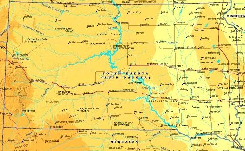
 | UNITED STATES OF AMERICA : SOUTH DAKOTA
|
| General useful information |
| Note: some data are of constant value, while other are due to changes, fluctuations etc. |
| State and population |
| capital: Pierre // state code ISO: SD ; FIPS: US46 |
| surface: 196570 sq.km = 75900 sq.mi // rank in USA: 16 // location: West North Central |
| climate: chracterized by extremes of temperature, persistent winds, low precipitation and humidity |
| entered USA as 40th state on: 1889-11-02 |
| administrative division: 66 counties |
| total population according to the census of 2000: 754,844 |
| population density 2000: 4 per sq.km = 10 per sq.mi // net growth 1999-2000: 8,5% |
| main ethnic groups: white 88,7%; black 0,6%; Asian 0,6%; Native American/Nat. AK 8,3%; other <2% |
| Economy and infrastructure |
| chief crops: corn, soybeans, oats, wheat, sunflowers, sorghum |
| livestock (million): cattle: 4,1 / pigs: 1,4 / poultry: 2,5 (excl. broilers) / sheep: 0,42 |
| timber/lumber: ponderosa pine |
| chief industries: agriculture, services, manufacturing |
| chief industrial products: food & kindred products, machinery, electric & electronic equipment |
| chief mining products: gold, portland cement, sand & gravel, crushed & dimension stone |
| Some physical landmarks |
| highest point in the state: Harney Pk 2207 m = 7242 ft |
| other mountains: Bear Mts. 2184, Croks Tower 2175, Custer Pk 2074 |
| lowest point in the state: ca 335 m in the SE corner near Elk Point |
| lakes: Waubay Lake, Lake Thompson, Lake Poinsett |
| artificial lakes: L. Oahe, L. Francis Case, Lewis and Clark L., Big Stone L., Shadehill Res., Angostura Res. |
| rivers: Missouri, James, White, Cheyenne, Moreau, Grand, Big Sioux |
| others: islands: none // deserts: none |
| Additional remarks, especially on the statistical information |
| other important features: |
| nick name(s): Coyote State, Mount Rushmore State |
| motto: Under God, the people rule |
| song: Hail, South Dakota |
| flower: Pasqueflower // bird: Chinese ring-necked pheasant // tree: Black Hills spruce |
| primary sources: |
| World almanac and book of facts; National Geographic Atlas of the World; maps: WN world @tlas |
 Back to the page containing general information of the whole country
 To the page containing the population growth statistics of the whole country
 to the secondary administrative division of the state
 To the page containing historical population statistics of some important towns of the state
 To the page containing urban historical population statistics of the whole country
 Back to the homepage of this website: POPULATION STATISTICS
File created on 2003.03.05 by Jan Lahmeyer
© "populstat" site: Jan Lahmeyer