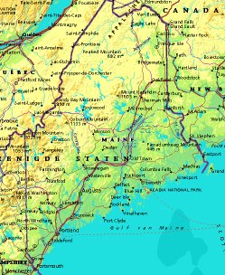
 | UNITED STATES OF AMERICA : MAINE
|
| General useful information |
| Note: some data are of constant value, while other are due to changes, fluctuations etc. |
| State and population |
| capital: Augusta // state code ISO: ME; FIPS: US23 |
| surface: 79941 sq.km = 30867 sq.mi // rank in USA: // location: northeastern New England |
| climate: southern and coastal part moderate maritime, northern part a bit more continental |
| entered USA as 23rd state on: 1820-03-15 |
| administrative division: 16 counties |
| total population according to the census of 2000: 1,274,923 |
| population density 2000: 16 per sq.km = 41 per sq.mi // net growth 1999-2000: 3,8% |
| main ethnic groups: white 96,9%; black 0,5%; Asian 0,7%; Native Amer./Nat. AK 0,6%; other 1,5% |
| Economy and infrastructure |
| chief crops: potatoes, aquaculture products |
| livestock (million): cattle: 0,097 / pigs: 0,006 / poultry: 5,7 |
| timber/lumber: pine, spruce, fir |
| chief industries: manufacturing, agriculture, fishing, services, trade, government, finance, insurance |
| chief industrial products: paper & wood products, transportation equipment |
| chief mining products: sand & gravel, portland & masonry cement, crushed stone, peat |
| Some physical landmarks |
| highest point in the state: Mt. Katahdin 1606 m = 5268 ft |
| other mountains: Bigelow Mt. 1265, Mt. Abraham 1234, Big Spencer Mt. 985, Mt. Blue 971 |
| lowest point in the state: sea level |
| lakes: Moosehead Lake, Chamberlain L., Chesuncook L., Grand L., Big L., Graham L., Sebago L. |
| artificial lakes: Flagstaff Lake, Richardson Lakes |
| rivers: Penobscot, Kennebec, Saint John, Aroostook, Androscoggin |
| others: islands: Mt. Desert Island, Vinalhaven, Isle au Haut, Deer Isle // deserts: none |
| Additional remarks, especially on the statistical information |
| other important features: |
| nick name(s): Pine Tree State |
| motto: Dirigo (I direct) |
| song: State of Maine Song |
| flower: White pine cone and tassel // bird: Chickadee // tree: Eastern white pine |
| primary sources: |
| World almanac and book of facts; National Geographic Atlas of the World; maps: WN world @tlas |
 Back to the page containing general information of the whole country
 To the page containing the population growth statistics of the whole country
 to the secondary administrative division of the state
 To the page containing historical population statistics of some important towns of the state
 To the page containing urban historical population statistics of the whole country
 Back to the homepage of this website: POPULATION STATISTICS
File created on 2003.02.28 by Jan Lahmeyer
© "populstat" site: Jan Lahmeyer