All countries of the world listed from A-Z:

or choose from the countries per continent below:


 |  |  |  |  |  |
 | NORTH KOREA[Chõson] : |
| General useful information |
| Note: some data are of constant value, while other are due to changes, fluctuations etc. |
| Nation and population |
| official name (short form): Chosõn |
| country code ISO: KP //; - FIPS: KN |
| location: East Asia |
| time zone: +9 UT |
| surface (land) area: 122762 sq.km = 47399 sq.mi //; - area incl. inland waters: sq.km = sq.mi |
| geographical position in extreme co-ordinates: North: 43° N / South: 38° N / East: 131° E / West: 124° E |
| borders (land): China, Russian Federation, South Korea |
| borders (coastline): Korea Bay, Yellow Sea, East Sea [also referred as: Sea of Japan] (all parts of the NW Pacific Ocean) |
| climate: continental |
| Government |
| independent since: 1948-09-09 |
| type of government: people's republic |
| capital: P'yõngyang |
| administrative division: province (9), special city (3), special district (1) |
| Population |
| population according to the latest census (1993): 21213,378 |
| total population according to the estimate of midyear 2000: 22268,000; 2001: 24063,000 |
| population density: 182 per sq.km = 470 per sq.mi |
| population growth: 1,7% //; - doubling time: 39 years |
| birth rate: 19 - 22 per 1000 |
| death rate: 5 -7 per 1000 |
| fertility rate: 2 children per female |
| maternal mortality: 41 per 100,000 |
| infant mortality (1-4 years): 23 per 1000 |
| life expectancy: 71 years (male: 68; female: 74) |
| age breakdown: 0-14 years: 29% //; - 15-59 years: 65% //; - 60+ years: 7% |
| urbanisation: 60% //; - urbanisation growth: 4% |
| percentage of urban population in the greatest city: 12% |
| Ethnic composition, language, religion |
| ethnic groups: Korean 99,8%; Chinese 0,2% |
| languages: Korean (official); Chinese |
| religious affiliation: traditional beliefs 16%; Chondogyo 14%; Buddhist 2%; Christian 1%; non religious 66% |
| Health |
| daily food intake: 1899 calories per capita |
| population with access to safe water: % |
| people per physician: 370 |
| people per hospital bed: |
| Education, literacy |
| school enrolment: primary education 6-11 years: % |
| school enrolment: secondary education: % |
| school enrolment: tertiary education 20-24 years: % |
| adult literacy: 95% (male: %; female: %) |
| Economy and infrastructure |
| Economy and trade |
| currency: Won = 100 chõn |
| annual inflation rate: 5% |
| population below poverty line: % |
| Gross Domestic Product: USD 1390 per capita |
| GNI USD per capita //; - [ppp: ] |
| GDP growth: % |
| income: USD 1100 per capita |
| import: USD 2238 per capita //; - export: USD 1095 per capita |
| trade: USD 200 per capita //; - or % of GDP |
| trade partners: CH RU JP |
| human development index: //; - position of the country in the world no.: |
| female labour force: 43% |
| unemployment: % |
| tourism: 0,1 million |
| Economic activities in agriculture, fisheries, industry, mining, services, energy |
| land use: arable land: 17% //; - grass land: % //; - wooded area: 74% //; - arid land and desert: % |
| agriculture: labour force: 43% //; - part of agriculture in GDP: % |
| agricultural products: rice, maize, potatoes, cabbages, soybeans, fruit |
| livestock (million): cattle: 0,6 / goats: 2,3 / pigs: 3,1 / poultry: 15,7 / sheep: 0,2 |
| fish catch: 210000 metric tonnes |
| industry: labour force: 30% //; - part of industry in GDP: % |
| industrial products: cement, crude steel, pig iron, coke, fertilizers, textiles, chemicals, machinery, food processing |
| mining products: coal, iron, lead, copper, zinc, tin, silver, gold, uranium, tungsten, graphite, magnesite, salt, lignite |
| CO2 emission per capita: 10,3 |
| services: labour force: 27% //; - part of services in GDP: % |
| energy use (kg per capita): 2658 |
| electricity use (per capita): |
| annual water use (per capita): 687 |
| Traffic, communication |
| road network: 23000, or 31200 km //; - of which paved: 6% //; - of which are motorways: 354 km |
| vehicles: 11 per 1000 |
| railways: 5045, or 8533 km //; - railways passenger/km: 3400 |
| navigable inland waterways: 2253 km |
| ownership telephone: 46 per 1000 |
| ownership radio receivers: 110 - 200 per 1000 |
| ownership tv-sets: 85 - 115 per 1000 |
| newspaper circulation: 213 per 1000 |
| persons per post office: |
| personal computers: per 1000 |
| Some physical landmarks |
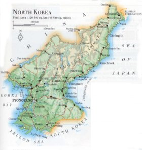
| mountains: Paektu-san 2744 m, Kwanmo-bong 2540, Puksubaek-san 2520 |
| lowest point: sea level |
| lakes (natural): none, or unknown |
| lakes (artificial reservoirs): several, of which Sup'ung-ho is the largest one |
| lakes (deepest): unknown |
| rivers: Ch'õngch'õn, Nam, Tumen, Yalu, Taedong |
| canals: none, or unknown |
| waterfalls: none, or unknown |
| caves: longest system: none, or unknown / deepest: unknown |
| islands: some small islands like Simm-do, Ka-do, Sok-to, Cho-do |
| deserts: none |
| other natural features: unknown |
| Additional remarks, especially on the statistical information |
| other important features: |
| apart from physical landmarks most of the above figures are changeable, in most cases they date from the 1990's |
| primary sources used for the general information: |
| BB CA EV PW WA WB WR, and some national statistical yearbooks |
| particulars concerning population data: |
 To the page containing the population growth statistics of the country
 To the page containing historical population statistics of the actual administrative division
To the page containing urban historical population statistics
 Back to the homepage of this website: POPULATION STATISTICS
Internet website:Latest modification of this page on 2006-06-26 by Jan Lahmeyer
© "Populstat" website: Jan Lahmeyer