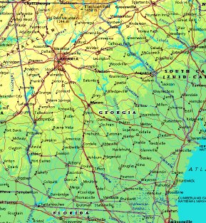
 | UNITED STATES OF AMERICA : GEORGIA
|
| General useful information |
| Note: some data are of constant value, while other are due to changes, fluctuations etc. |
| State and population |
| capital: Atlanta // state code ISO: GA ; FIPS: US13 |
| surface: 150026 sq.km = 57823 sq.mi // rank in USA: 21 // location: South Atlantic |
| climate: maritime tropical air masses dominate in summer, polar air masses in winter |
| entered USA as 4th state ratifying the Constitution on: 1788-01-02 |
| administrative division: 159 counties |
| total population according to the census of 2000: 8,816,453 |
| population density 2000: 59 per sq.km = 152 per sq.mi // net growth 1999-2000: 26,4% |
| main ethnic groups: white 65%; black 29%; Asian 2%; other 4% |
| Economy and infrastructure |
| chief crops: peanuts, cotton, corn, tobacco, hay, soybeans |
| livestock (million): cattle: 1,3 / pigs: 0,38 / poultry: 30, broilers 1200 |
| timber/lumber: pine, hardwood |
| chief industries: services, manufacturing, retail trade |
| chief industrial products: textiles, apparel, food & kindred products, pulp & paper products |
| chief mining products: crushed stone, portland cement, sand & gravel |
| Some physical landmarks |
| highest point in the state: Brasstown Bald 1458 m = 4784 ft |
| other mountains: Rabun Bald 1431, Blood Mt. 1359, Big Bald Mt. 1244, Springer Mt. 1153 |
| lowest point in the state: sea level |
| lakes: no natural lakes of importance // swamp: Okefenokee Swamp |
| artificial lakes: Sidney Lanier, Clarks Hill, West Point, Walter F. George Res., L. Sinclair, L. Oconee |
| rivers: Savannah, Ogeechee, Altamaha, Flint, Chattahoochee |
| others: islands: St. Catherines Island, Jekyll Island, Sapelo Island, St. Simons Island // deserts: none |
| Additional remarks, especially on the statistical information |
| other important features: |
| nick name(s): Empire State of the South, Peach State |
| motto: Wisdom, justice and moderation |
| song: Georgia on my mind |
| flower: Cherokee rose // bird: Brown thrasher // tree: Live oak |
| primary sources: |
| World almanac and book of facts; National Geographic Atlas of the World; maps: WN world @tlas |
 Back to the page containing general information of the whole country
 To the page containing the population growth statistics of the whole country
 to the secondary administrative division of the state
 To the page containing historical population statistics of some important towns of the state
 To the page containing urban historical population statistics of the whole country
 Back to the homepage of this website: POPULATION STATISTICS
File created on 2003.02.22 by Jan Lahmeyer
© "populstat" site: Jan Lahmeyer