All countries of the world listed from A-Z:

or choose from the countries per continent below:


 |  |  |  |  |  |
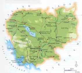 | CAMBODIA[Kampuchea ; Khmer] : |
| General useful information |
| Note: some data are of constant value, while other are due to changes, fluctuations etc. |
| Nation and population |
| official name (short form): Kampuchea |
| country code ISO: KH [KHM] //; - FIPS: CB |
| location: Southeast Asia |
| time zone: +7 UT |
| surface (land) area: 176520 sq.km = 68154 sq.mi //; - area incl. inland waters: 181035 sq.km = 69898 sq.mi |
| geographical position in extreme co-ordinates: North: 10° N / South: 15° N / East: 108° E / West: 103° E |
| borders (land): Thailand, Laos, Vietnam |
| borders (coastline): Gulf of Thailand |
| climate: tropical |
| Government |
| independent since: 1953-11-09 |
| type of government: republic |
| capital: Pnom Penh |
| administrative division: province (18) [or: 20] + municipality (2) [or: 3 / 4] |
| Population |
| population according to the latest census: (1998) 11426,223 ; or: 11437,656 |
| total population according to the estimate of midyear 2000: 12212,306 ; or: 12021,000 /; 2001: 12350,000 /; 2002: 12487,000 |
| population density: 67 per sq.km = 175 per sq.mi |
| population growth: 2,9% //; - doubling time: ca 35 years |
| birth rate: 33 - 43 per 1000 |
| death rate: 11 - 15 per 1000 |
| fertility rate: 4 children per female |
| maternal mortality: per 100,000 |
| infant mortality (in the first year of life): 138 - 166 per 1000 |
| infant mortality (from 1st - 4th year of life): 96 - 116 per 1000 |
| life expectancy: 51 - 57 years (male: 49 - 55; female: 52 - 59) |
| age breakdown: 0-14 years: 35% //; - 15-59 years: 60% //; - 60+ years: 5% |
| urbanisation: 16 - 21% //; - urbanisation growth: 3,6% |
| percentage of urban population in the greatest city: ca 75% |
| Ethnic composition, language, religion |
| ethnic groups: Khmer 89 - 94%; Chinese 2 - 4%; Vietnamese 1 - 7%; Thai, Cham, Moi |
| languages: Khmer, French, Chinese, Vietnamese |
| religious affiliation: Theravada Buddhism 95% [FW: 88%]; Muslim 2%; other 3% |
| Health |
| daily food intake: 2078 calories per capita |
| population with access to safe water: 13% [FW 2000: 30%] |
| people per physician: 25000 [DK: 3333] |
| people per hospital bed: 950 |
| Education, literacy |
| school enrolment: primary education 6-11 years: 77% [FW 2001: 86%] |
| school enrolment: secondary education: 9% [FW 2001: 21%] |
| school enrolment: tertiary education 20-24 years: 1% [DK: 3%] |
| adult literacy: 75% (male: 85%; female: 65%) [FW 2000: m: 80%; f: 57%] |
| Economy and infrastructure |
| Economy and trade |
| currency: Riel (CR) = 100 sen |
| annual inflation rate: 22 - 25% |
| population below poverty line: 36% |
| Gross Domestic Product: USD 193 per capita |
| GNI USD 260 - 300 per capita //; - [ppp: 1440 - 1970] |
| GDP growth: 2% |
| income: USD 200 - 270 per capita |
| import: USD 404 per capita //; - export: USD 219 per capita |
| trade: USD 25 per capita //; - or 40% of GDP |
| trade partners: RU EU TR JP US AU SG TH CN VN |
| human development index: 0,541 //; - position of the country in the world no.: 121 |
| female labour force: 52% |
| unemployment: 3,5% |
| tourism: 0,3 - 0,5 million |
| Economic activities in agriculture, fisheries, industry, mining, services, energy |
| land use: arable land: 17% //; - grass land: 3% //; - wooded area: 76% //; - arid land and desert: % |
| agriculture: labour force: 74% //; - part of agriculture in GDP: 90% |
| agricultural products: rice, com, rubber, vegetables, fishing |
| livestock (million): buffalo: 0,8 / cattle: 2,9 / pigs: 2,1-2,6 / poultry: 15-23 [chickens 11-17, ducks: 3-6] |
| fish catch: 269100 - 298798 metric tonnes |
| industry: labour force: 7 - 8% //; - part of industry in GDP: 6% |
| industrial products: iron and steel, rubber, wood products |
| mining products: salt, iron ore, phosphates, gemstones, manganese |
| CO2 emission per capita: 0,1 |
| services: labour force: 18 - 19% //; - part of services in GDP: 4% |
| energy use (kg per capita): 52 |
| electricity use (per capita): |
| annual water use (per capita): 64 |
| Traffic, communication |
| road network: 13351; or: 35769 km //; - of which paved: 16 - 34% [1996] //; - of which are motorways: 0 km |
| vehicles: 6 - 26 per 1000 // international license plate: K |
| railways: 601 - 612 km //; - railways passenger/km: 54 |
| navigable inland waterways: 2400 - 3700 km |
| ownership telephone: 2 - 3 per 1000 // international dialling code: +855 |
| ownership radio receivers: 124 - 150 per 1000 |
| ownership tv-sets: 7 - 9 per 1000 |
| newspaper circulation: 4 per 1000 |
| persons per post office: 328000 |
| personal computers: 1 per 1000 |
| Some physical landmarks |
| mountains: Phnum Aôral 1771 m |
| lowest point: sea level |
| lakes (natural): Tônlé Sap |
| lakes (artificial reservoirs): unknown |
| lakes (deepest): unknown |
| rivers: Mekong, Sab, Basak |
| canals: unknown |
| waterfalls: unknown |
| caves: longest system: unknown / deepest: |
| islands: Kaôh Rûng, Kaôh Rûng Sâmlôen, Kaôh Kông |
| deserts: none |
| other natural features: |
| Additional remarks, especially on the statistical information |
| other important features: |
| apart from physical landmarks most of the above figures are changeable, in most cases they date from the 1990's |
| primary sources used for the general information: |
| BB CA DK EV FW PW WA WB WR, and some - local national or international - statistical yearbooks |
| particulars concerning population data: |
 To the page containing the population growth statistics of the country
 To the page containing the historical population growth statistics of the provinces
 To the page containing urban historical population statistics
 Back to the homepage of this website: POPULATION STATISTICS
Internet website: Internet website:Latest modification of this page on 2004-12-22 by Jan Lahmeyer
© "Populstat" website: Jan Lahmeyer