All countries of the world listed from A-Z:

or choose from the countries per continent below:


 |  |  |  |  |  |
 | BANGADESHgeneral data of the country |
| General useful information |
| Note: some data are of constant value, while other are due to changes, fluctuations etc. |
| Nation and population |
| official name (short form): Bangladesh |
| country code ISO: BD [BGD] //; - FIPS: BG |
| location: South Asia |
| time zone: +6 UT |
| surface (land) area: 130170 sq.km = 50259 sq.mi //; - area incl. inland waters: 147570 sq.km = 56977 sq.mi |
| geographical position in extreme co-ordinates: North: 26° 38' N / South: 20° 34' N / East: 92° 41' E / West: 88° 01' E |
| borders (land): India, Myanmar |
| borders (coastline): Bay of Bengal |
| climate: tropical monsoon |
| Government |
| independent since: (proclamation on 1971-03-26) 1971-12-16 of 1971-12-17 |
| type of government: republic |
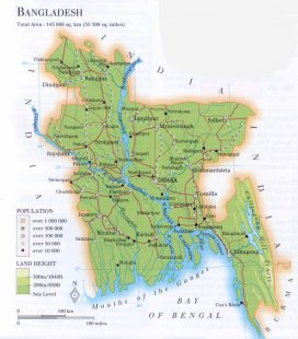
| capital: Dhaka (Dacca) |
| administrative division: division (4) into region (21) or zila (64) and thana/upazila (507) // municipalities 254 [2001-08] |
| Population |
| population according to the last two censuses: (1991): 111455,185 //; - 2001: 123151,246 |
| total population according to the estimate of midyear 2000: 129194,224 // ; 2001: 131221,000 // ; 2002: 135684,000 |
| population density: 920 per sq.km = 2382 per sq.mi [on land area: 999 per sq.km = 2586 per sq.mi] |
| population growth: 2,3% //; - doubling time: 30 years |
| birth rate: 41 [30] per 1000 |
| death rate: 14 [11] per 1000 |
| fertility rate: 4 children per female |
| maternal mortality: per 100,000 |
| infant mortality (in the first year of life): 73 per 1000 |
| infant mortality (from 1st - 4th year of life): 48 - 100 per 1000 |
| life expectancy: 57 years (male: 57; female: 57) |
| age breakdown: 0-14 years: 44% //; - 15-59 years: 52% //; - 60+ years: 5% |
| urbanisation: 24-26% //; - urbanisation growth: 3% |
| percentage of urban population in the greatest city: 30% |
| Ethnic composition, language, religion |
| ethnic groups: Bengali 98,8%, Bihari; tribal 1,1%; such as Chakma, Saontal, Marma |
| languages: Bengali; English and nearly 100 tribal dialects |
| religious affiliation: Islam (sunni) 88,3%; Hindu 10,5%; Buddhist 0,6%; Christian 0,3% |
| Health |
| daily food intake: 2050 calories per capita |
| population with access to safe water: 84% [FW 2002: 97%] |
| people per physician: 4759 [PG 1999: 12500] |
| people per hospital bed: 3312 |
| Education, literacy |
| school enrolment: primary education 6-11 years: 79% [FW 2002: 87%] |
| school enrolment: secondary education: 17% [FW 2002: 44%; DK 46%] |
| school enrolment: tertiary education 20-24 years: 4% [DK: 7%] |
| adult literacy: 35% [DK: 41%] (male: 45%; female: 24%) [FW 2002: m 49% ; f 30%] |
| Economy and infrastructure |
| Economy and trade |
| currency: Bangladesh taka (Tk.) = 100 paisa |
| annual inflation rate: 4% |
| population below poverty line: 36% |
| Gross Domestic Product: USD 230 per capita |
| GNI USD 370 per capita //; - [ppp: 1590 - 1770] |
| GDP growth: 3% |
| income: USD 220 - 240 per capita |
| import: USD 2709 per capita //; - export: USD 2138 per capita |
| trade: USD 43-54 per capita //; - or 31,5% of GDP |
| trade partners: US JP IN CA KR CH SG WEU |
| human development index: 0,47 //; - position of the country in the world no.: 132 |
| female labour force: 42% |
| unemployment: 36% |
| tourism: 0,2 million |
| Economic activities in agriculture, fisheries, industry, mining, services, energy |
| land use: arable land: 68-70% //; - grass land: 5% //; - wooded area: 14-15% //; - arid land and desert: % |
| agriculture: labour force: 57-59 [65]% //; - part of agriculture in GDP: 30-36% |
| agricultural products: rice, jute, sugar cane, cattle, fish, timber, tea, wheat, tobacco |
| livestock (million): buffalo: 0,9 / cattle: 24 / ducks: 16 / goats: 34 / horses 0,05 / poultry: 153 / sheep: 1,1 |
| fish catch: 924056 - 1660000 metric tonnes |
| industry: labour force: 10-13 [11]% //; - part of industry in GDP: 16-17% |
| industrial products: jute, textiles, sugar, glass, fertilizers, steel |
| mining products: natural gas, sand, lignite, limestone, ceramic clay, salt |
| CO2 emission per capita: 0,2 |
| services: labour force: 28-34 [25]% //; - part of services in GDP: 48-52% |
| energy use (kg per capita): 139 |
| electricity use (per capita): 89 |
| annual water use (per capita): 220 |
| Traffic, communication |
| road network: 193283 km //; - of which paved: 4-9% [19773] //; - of which are motorways: 0 km |
| vehicles: 0,4 - 1 per 1000 // international license plate: BD |
| railways: 2706 - 2745 km //; - railways passenger/km: 4037 |
| navigable inland waterways: 8046 - 8433 km |
| ownership telephone: 2,4 - 4 per 1000 // international dialling code: +880 |
| ownership radio receivers: 67 per 1000 |
| ownership tv-sets: 7 per 1000 |
| newspaper circulation: 6 per 1000 |
| persons per post office: |
| personal computers: 1,5 per 1000 |
| Some physical landmarks |
| mountains: Reng Tlang 957 m |
| lowest point: sea level |
| lakes (natural): unknown |
| lakes (artificial reservoirs): Karnafuli Reservoir |
| lakes (deepest): unknown |
| rivers: Padma (Ganges), Jamuna (Brahmaputra), forming Meghna, this splits into 4 mouths; Teesta, Surma, Kamaphuli |
| canals: unknown |
| waterfalls: none |
| caves: longest system: unknown / deepest: |
| islands: numerous islands in the delta (mouths of the Ganges) |
| deserts: none |
| other natural features: |
| Additional remarks, especially on the statistical information |
| other important features: |
| apart from physical landmarks most of the above figures are changeable, in most cases they date from the 1990's |
| due to a constant cycle of floods and famine Bangladesh is considered to be a "pitiful" country |
| primary sources used for the general information: |
| BB CA DK EV FW PW WA WB WR, and some - local national or international - statistical yearbooks |
| particulars concerning population data: |
| At each census there is a possible underenumeration of 3-5% |
 To the page containing the population growth statistics of the country
 To the page containing the historical population growth statistics of the provinces
 To the page containing urban historical population statistics
 Back to the homepage of this website: POPULATION STATISTICS
Internet website: Internet website:Latest modification of this page on 2004-12-21 by Jan Lahmeyer
© "Populstat" website: Jan Lahmeyer