All countries of the world listed from A-Z:

or choose from the countries per continent below:


 |  |  |  |  |  |
 | PARAGUAYgeneral data of the country |
| General useful information |
| Note: some data are of constant value, while other are due to changes, fluctuations etc. |
| Nation and population |
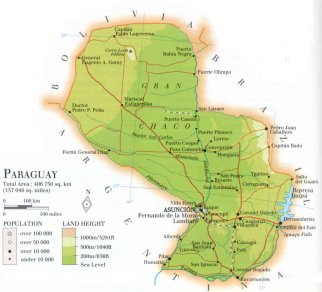
| official name (short form): Paraguay |
| country code ISO: PY //; - FIPS: PA |
| location: Central South America |
| time zone: -4 UT |
| surface (land) area: 406752 sq.km = 157408 sq.mi //; - area incl. inland waters: sq.km = sq.mi |
| geographical position in extreme co-ordinates: North: 19° S / South: 27° S / East: 54° W / West: 63° W |
| borders (land): Bolivia, Brazil, Argentina |
| borders (coastline): none |
| climate: subtropical |
| Government |
| independent since: 1811-05-14 |
| type of government: republic |
| capital: Asunción |
| administrative division: región (2) ; departamento (18) |
| Population |
| population according to the latest census (1992): 4152,588 |
| total population according to the estimate of midyear 2000: 5585,828; or: 5496,000 -; 2001: 5291,000, or 5734,139 |
| population density: 13,5 per sq.km = 35 per sq.mi |
| population growth: 3% //; - doubling time: 26 years |
| birth rate: 31 - 35 per 1000 |
| death rate: 5 -6 per 1000 |
| fertility rate: 5 children per female |
| maternal mortality: 380 per 100,000 |
| infant mortality (1-4 years): 47 per 1000 |
| life expectancy: 74 years (male: 71; female: 77) |
| age breakdown: 0-14 years: 40% //; - 15-59 years: 55% //; - 60+ years: 5% |
| urbanisation: 56% //; - urbanisation growth: 4% |
| percentage of urban population in the greatest city: 44% |
| Ethnic composition, language, religion |
| ethnic groups: mestizo (Spanish-Guaraní) 90,8%; Amerindian 3%; German 1,7%; other 4,5% |
| languages: Spanish 60% (official); Guaraní 40% |
| religious affiliation: Roman Catholic 88%; Protestant 5%; other 7% |
| Health |
| daily food intake: 2577 calories per capita |
| population with access to safe water: 39 - 79% |
| people per physician: 1400 |
| people per hospital bed: |
| Education, literacy |
| school enrolment: primary education 6-11 years: 98% |
| school enrolment: secondary education: 25% |
| school enrolment: tertiary education 20-24 years: 8% |
| adult literacy: 92% (male: %; female: %) |
| Economy and infrastructure |
| Economy and trade |
| currency: Guaraní = 100 céntimos |
| annual inflation rate: 12,5% |
| population below poverty line: 22% |
| Gross Domestic Product: USD 3980 per capita |
| GNI USD 1440 per capita //; - [ppp: 4450] |
| GDP growth: -0,4% |
| income: USD 1210 per capita |
| import: USD 3136 per capita //; - export: USD 820 per capita |
| trade: USD 447 per capita //; - or 40% of GDP |
| trade partners: BR AG US NL DZ CH |
| human development index: 0,738 //; - position of the country in the world no.: 80 |
| female labour force: 30% |
| unemployment: 8% |
| tourism: 0,3 million |
| Economic activities in agriculture, fisheries, industry, mining, services, energy |
| land use: arable land: 6% //; - grass land: 53% //; - wooded area: 35% //; - arid land and desert: % |
| agriculture: labour force: 49% //; - part of agriculture in GDP: 22% |
| agricultural products: sugarcane, cassava, soybeans, maize, seed cotton, oranges, bananas, cotton |
| livestock (million): cattle: 9,8 / goats: 0,1 / horses: 0,4 / pigs: 2,7 / poultry: 15-25 / sheep: 0,4 |
| fish catch: 25000 - 28000 metric tonnes |
| industry: labour force: 21% //; - part of industry in GDP: 24% |
| industrial products: food products, wood products, handicrafts, textiles, cement |
| mining products: iron, manganese, limestone, kaolin, gypsum |
| CO2 emission per capita: 0,9 |
| services: labour force: 31% //; - part of services in GDP: 54% |
| energy use (kg per capita): 773 |
| electricity use (per capita): 789 |
| annual water use (per capita): 109 |
| Traffic, communication |
| road network: 23606, or 29500 km //; - of which paved: 10% //; - of which are motorways: 705 km [Pan American Highway] |
| vehicles: 35 per 1000 |
| railways: 441, or: 970 km //; - railways passenger/km: 2 |
| navigable inland waterways: 3100 km |
| ownership telephone: 34 - 55 per 1000 |
| ownership radio receivers: 141 - 182 per 1000 |
| ownership tv-sets: 101 - 144 per 1000 |
| newspaper circulation: 42 per 1000 |
| persons per post office: 15000 |
| personal computers: 13 per 1000 |
| Some physical landmarks |
| mountains: Cerro León 1000 m |
| lowest point: ca 58 m, at the merging of the Paraguay and Paraná in the southern tip of the country |
| lakes (natural): Laguna Vera |
| lakes (artificial reservoirs): Represa de Acaray, Represa de Itaipú (on the border with Brazil) |
| lakes (deepest): unknown |
| rivers: Paraguay, Paraná, Pilcomayo |
| canals: none, or unknown |
| waterfalls: none, or unknown |
| caves: longest system: none, or unknown / deepest: |
| islands: none |
| deserts: none |
| other natural features: |
| Additional remarks, especially on the statistical information |
| other important features: |
| apart from physical landmarks most of the above figures are changeable, in most cases they date from the 1990's |
| primary sources used for the general information: |
| BB CA EV PW WA WB WR, and some national statistical yearbooks |
| particulars concerning population data: |
 To the page containing the population growth statistics of the country
 To the page containing the historical population growth statistics of the provinces
 To the page containing urban historical population statistics
 Back to the homepage of this website: POPULATION STATISTICS
Internet website:Latest modification of this page on 2004-03-01 by Jan Lahmeyer
© "populstat" site: Jan Lahmeyer