All countries of the world listed from A-Z:

or choose from the countries per continent below:


 |  |  |  |  |  |
 | HONDURASgeneral data of the country |
| General useful information |
| Note: some data are of constant value, while other are due to changes, fluctuations etc. |
| Nation and population |
| official name (short form): Honduras |
| country code ISO: HN //; - FIPS: HO |
| location: Central America |
| time zone: -5 UT |
| surface (land) area: 112090 sq.km = 43278 sq.mi //; - area incl. inland waters: sq.km = sq.mi |
| geographical position in extreme co-ordinates: North: 16° N / South: 13° N / East: 83° W / West: 89° W |
| borders (land): Guatemala, El Salvador, Nicaragua |
| borders (coastline): Caribbean Sea (Atlantic Ocean), Pacific Ocean |
| climate: tropical |
| Government |
| independent since: 1821-09-15 (proclaimed) ; 1838-10-26 (effective) |
| type of government: republic |
| capital: Tegucigalpa |
| administrative division: departamento (18) |
| Population |
| population according to the latest census (1988): 4376,839 |
| total population according to the estimate of midyear 2000: 6249,598 /or:/ 6417,000 /or:/ 6597,100 // - ; 2001: 6575,000 |
| population density: 58 per sq.km = 150 per sq.mi |
| population growth: 3,3% //; - doubling time: 24 years |
| birth rate: 32 - 37 per 1000 |
| death rate: 5 -7 per 1000 |
| fertility rate: 5 children per female |
| maternal mortality: 50 per 100,000 |
| infant mortality (1-4 years): 57 per 1000 |
| life expectancy: 66 - 69 years (male: 64 - 68; female: 68 - 71) |
| age breakdown: 0-14 years: 45% //; - 15-59 years: 50% //; - 60+ years: 5% |
| urbanisation: 53% //; - urbanisation growth: 5% |
| percentage of urban population in the greatest city: 33% |
| Ethnic composition, language, religion |
| ethnic groups: Mestizo 90%; Amerindian 7%; black 2%; white 1% |
| languages: Spanish, Black Carib (Garifuna) |
| religious affiliation: Roman Catholic 86,7%; Protestant 10,5%; other 2,8% |
| Health |
| daily food intake: 2343 calories per capita |
| population with access to safe water: 65% |
| people per physician: 3090 |
| people per hospital bed: |
| Education, literacy |
| school enrolment: primary education 6-11 years: 89% |
| school enrolment: secondary education: 21% |
| school enrolment: tertiary education 20-24 years: 8% |
| adult literacy: 73% (male: %; female: %) |
| Economy and infrastructure |
| Economy and trade |
| currency: Lempira = 100 centavos |
| annual inflation rate: 19% |
| population below poverty line: 53% |
| Gross Domestic Product: USD 600 per capita |
| GNI USD 860 per capita //; - [ppp: 2400] |
| GDP growth: 0,4% |
| income: USD 570 per capita |
| import: USD 1727 per capita //; - export: USD 656 per capita |
| trade: USD 321 per capita //; - or 71% of GDP |
| trade partners: US VE DE MX JP BE |
| human development index: 0,634 //; - position of the country in the world no.: 107 |
| female labour force: 32% |
| unemployment: 4% |
| tourism: 0,4 million |
| Economic activities in agriculture, fisheries, industry, mining, services, energy |
| land use: arable land: 16% //; - grass land: 23% //; - wooded area: 29% //; - arid land and desert: % |
| agriculture: labour force: 60% //; - part of agriculture in GDP: 22% |
| agricultural products: timber (hardwoods), bananas, coffee, cotton, flowers, [citrus] fruit |
| livestock (1000s): cattle: 1780 / goats: 31 / horses: 179 / mules: 70 / pigs: 470 / poultry: 17300 / sheep: 14 |
| fish catch: 7215 - 23585 metric tonnes |
| industry: labour force: 16% //; - part of industry in GDP: 27% |
| industrial products: textiles, wood products |
| mining products: lead, zinc, silver, gold, copper, iron, antimony, coal |
| CO2 emission per capita: 0,8 |
| services: labour force: 23% //; - part of services in GDP: 51% |
| energy use (kg per capita): 522 |
| electricity use (per capita): 449 |
| annual water use (per capita): 294 |
| Traffic, communication |
| road network: 11371, or 15100 km //; - of which paved: 20% //; - of which are motorways: 243 km [Pan American highway] |
| vehicles: 7 per 1000 |
| railways: 955, or: 988 km //; - railways passenger/km: 8 |
| navigable inland waterways: 465 km |
| ownership telephone: 29 - 44 per 1000 |
| ownership radio receivers: 337 - 386 per 1000 |
| ownership tv-sets: 90 per 1000 |
| newspaper circulation: 44 per 1000 |
| persons per post office: 12700 |
| personal computers: 11 per 1000 |
| Some physical landmarks |
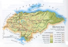
| mountains: Cerro Las Minas 2849 m, Santa Bárbara 2744, Sierra de Agalta 2590, Cerro El Homo 2470 |
| lowest point: sea level |
| lakes (natural): Lago de Yojoa |
| lakes (artificial reservoirs): Represa el Cajón |
| lakes (deepest): unknown |
| rivers: Coco, Alúa, Chamelecón, Aguán, Río Sico, Patuca, Goascorán, Choluteca |
| canals: none, or unknown |
| waterfalls: none, or unknown |
| caves: longest system: none, or unknown / deepest: |
| islands: Islas de la Bahía |
| deserts: none |
| other natural features: |
| Additional remarks, especially on the statistical information |
| other important features: |
| apart from physical landmarks most of the above figures are changeable, in most cases they date from the 1990's |
| if there is a range between the figures, the differences are due to the use of several sources |
| primary sources used for the general information: |
| BB CA EV PW WA WB WR, and some national statistical yearbooks |
| particulars concerning population data: |
 To the page containing the population growth statistics of the country
 To the page containing the historical population growth statistics of the provinces
 To the page containing urban historical population statistics
 Back to the homepage of this website: POPULATION STATISTICS
Internet website: Internet website:Latest modification of this page on 2004-02-16 by Jan Lahmeyer
© "populstat" site: Jan Lahmeyer