All countries of the world listed from A-Z:

or choose from the countries per continent below:


 |  |  |  |  |  |
 | ARGENTINAgeneral data of the country |
| General useful information |
| Note: some data are of constant value, while other are due to changes, fluctuations etc. |
| Nation and population |
| official name (short form): Argentina |
| country code ISO: AR [ARG] //; - FIPS: AR |
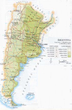
| location: southern South America |
| time zone: -3 UT |
| surface (land) area: 2736690 sq.km = 1056636 sq.mi //; - area incl. inland waters: 2780092 sq.km = 1073402 sq.mi |
| geographical position in extreme co-ordinates: North: 22° S / South: 55° S / East: 73° W / West: 54° W |
| borders (land): Chile, Bolivia, Paraguay, Brazil, Uruguay |
| borders (coastline): Atlantic Ocean |
| climate: several, raging from almost tropical via semi-arid to mild |
| Government |
| independent since: 1816-07-09 (or 1816-07-10) |
| type of government: federal republic |
| capital: Buenos Aires |
| administrative division: provincia (22) + distrito federal (1) + intendencia (1) |
| Population |
| population according to the last two censuses (1991): 32615,528; (2001): 36260,130 |
| total population according to the estimate of midyear 2000: 36955,182 ; or: 37032,000 //; or: 2002: 36480,000 |
| population density: 12 per sq.km = 35 per sq.mi |
| population growth: 1,2% //; - doubling time: 63 years |
| birth rate: 19 per 1000 |
| death rate: 8 per 1000 |
| fertility rate: 3 children per female |
| maternal mortality: 69 per 100,000 |
| infant mortality (in the first year of life): 19 per 1000 |
| infant mortality (from 1st - 4th year of life): 16 per 1000 |
| life expectancy: 75,5 years (male: 71-72; female: 78-79) |
| age breakdown: 0-14 years: 28% //; - 15-59 years: 57% //; - 60+ years : 15% |
| urbanisation: 87-88% //; - urbanisation growth: 1,5% |
| percentage of urban population in the greatest city: 45% |
| Ethnic composition, language, religion |
| ethnic groups: of European descent 85% (of Italian origin: 36%; of Spanish origin: 29%); Mestizo 5%; Amerindian |
| languages: Spanish, Italian, Guarani, Guaicurú, Quechua, Tehuelce |
| religious affiliation: Roman Catholic 88%; Protestant 7%; Muslim 2%; Jews 1%; others 2% |
| Health |
| daily food intake: 3144 calories per capita |
| population with access to safe water: 66% |
| people per physician: 329 - 376 |
| people per hospital bed: 304 |
| Education, literacy |
| school enrolment: primary education 6-11 years: 100% |
| school enrolment: secondary education: 81% [later figure: 97%] |
| school enrolment: tertiary education 20-24 years: 41% [later figure: 48%] |
| adult literacy: 97% (male: 97%; female: 97%) |
| Economy and infrastructure |
| Economy and trade |
| currency: (new) peso [arg$] = 100 centavos |
| annual inflation rate: 5% [later figure found: 13% and 26%] |
| population below poverty line: 18% |
| Gross Domestic Product: USD 7550 per capita |
| GNI USD 4220 - 7460 per capita //; - [ppp: 10600 - 2050] |
| GDP growth: 3% |
| income: USD 2760 per capita |
| import: USD 20122 per capita //; - export: USD 20963 per capita |
| trade: USD 877 per capita //; - or 18% of GDP |
| trade partners: US BR IT DE BO NL CL UR JP CN ES MX |
| human development index: 0,842 //; - position of the country in the world no.: 34 |
| female labour force: 33% |
| unemployment: 15% [later figure found: 18%] |
| tourism: 3 million |
| Economic activities in agriculture, fisheries, industry, mining, services, energy |
| land use: arable land: 9-10% //; - grass land: 52% //; - wooded area: 22% //; - arid land and desert: 15% |
| agriculture: labour force: 13% ; [later figure found: 10%] //; - part of agriculture in GDP: 15% [6-11%] |
| agricultural products: beef meat, wine, fruit, cotton, sunflower seeds, lemons, grapes, peanuts, corn |
| livestock (million): cattle: 52 / goats: 4,5 / horses: 3,6 / pigs: 3,2 - 4,5 / poultry: 55 - 110 / sheep: 14 - 17,3 |
| fish catch: 919500 - 1350000 metric tonnes |
| industry: labour force: 34% //; - part of industry in GDP: 30% [32%] |
| industrial products: cement, iron, steel, traffic equipment, textiles |
| mining products: coal, crude petroleum, natural gas, zinc, lead, silver, gold, tin, uranium, copper, iron |
| CO2 emission per capita: 3,8 |
| services: labour force: 53% [later figure found: 66%] //; - part of services in GDP: 45% [57-63%] |
| energy use (kg per capita): 1727 |
| electricity use (per capita): 1938 |
| annual water use (per capita): 1043 |
| Traffic, communication |
| road network: 216100 km //; - of which paved: 29% [63348 km] //; - of which are motorways: 734 or 4835 km |
| vehicles: 5,7 million ; or 140 per 1000 // international license plate: RA |
| railways: 34509 km //; - railways passenger/km: 190000 |
| navigable inland waterways: 11000 km |
| ownership telephone: 160 - 224 per 1000 // international dialling code: +54 |
| ownership radio receivers: 778 per 1000 |
| ownership tv-sets: 347 per 1000 |
| newspaper circulation: 138 per 1000 |
| persons per post office: 6100 |
| personal computers: 51 per 1000 |
| Some physical landmarks |
| mountains: Cerro Aconcagua 6959 m, C. Bonete 6872, C. Ojos del Salado 6863, C. Tupungato 6800, Monte Pissis 6779, C. Mercedario 6770 |
| lowest point: Península Valdés 48 m below sea level |
| lakes (natural): Argentino 1415 km2, Viedma 1088, L. Buenos Aires 881, Colhue Huapi 803 |
| lakes (artificial reservoirs): unknown |
| lakes (deepest): unknown |
| rivers: Paraná 1800 km, Río Negro 635, R. Colorado 860, R. Salado 2000, R. Bermejo-Teuco 1000, Pilcomayo 850, Uruguay 1100 |
| canals: unknown |
| waterfalls: Iguazu 70 m |
| caves: longest system: / deepest: |
| islands: Terra del Fuego (eastern part) |
| deserts: Patagonia (semi-desert) |
| other natural features: |
| Additional remarks, especially on the statistical information |
| other important features: |
| apart from physical landmarks most of the above figures are changeable, in most cases they date from the 1990's |
| primary sources used for the general information: |
| BB CA DK EV FW PW WA WB WR, and some - local national or international - statistical yearbooks |
| particulars concerning population data: |
 To the page containing the population growth statistics of the country
 To the page containing the historical population growth statistics of the provinces
 To the page containing urban historical population statistics
 Back to the homepage of this website: POPULATION STATISTICS
Internet website:Latest modification of this page on 2004-12-20 by Jan Lahmeyer
© "Populstat" website: Jan Lahmeyer