All countries of the world listed from A-Z:

or choose from the countries per continent below:


 |  |  |  |  |  |
 | TUNISIAgeneral data of the country |
| General useful information |
| Note: some data are of constant value, while other are due to changes, fluctuations etc. |
| Nation and population |
| official name (short form): Tûnusîya |
| country code ISO: TN //; - FIPS: TS |
| location: North Africa |
| time zone: +1 UT |
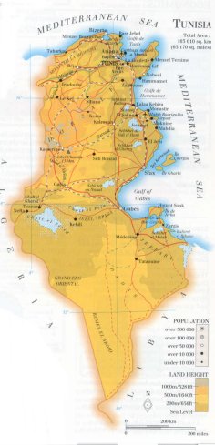
| surface (land) area: 163610 sq.km = 63170 sq.mi //; - area incl. inland waters: sq.km = sq.mi |
| geographical position in extreme co-ordinates: North: 37° N / South: 30° N / East: 12° E / West: 8° E |
| borders (land): Libya, Algeria |
| borders (coastline): Mediterranean Sea |
| climate: Mediterranean, regional differences: N humid, S arid |
| Government |
| independent since: 1956-03-20 |
| type of government: republic |
| capital: Tunis |
| administrative division: wilayat [=governorate] (23) |
| Population |
| population according to the latest census (1994): 8785,364 |
| total population according to the estimate of midyear 2000: 9564,000; or: 9593,402 /-; 2001: 9673,000; or: 9705,102 |
| population density: 59 per sq.km = 152 per sq.mi |
| population growth: 2% //; - doubling time: 44 years |
| birth rate: 17 - 21 per 1000 |
| death rate: 5 per 1000 |
| fertility rate: 3 children per female |
| maternal mortality: 310 per 100,000 |
| infant mortality (1-4 years): 43 per 1000 |
| life expectancy: 74 years (male: 72; female: 76) |
| age breakdown: 0-14 years: 38% //; - 15-59 years: 56% //; - 60+ years: 6% |
| urbanisation: 63% //; - urbanisation growth: 4% |
| percentage of urban population in the greatest city: 30% |
| Ethnic composition, language, religion |
| ethnic groups: Arab 98,2%; Berber 1,2%; French 0,2%; Italian 0,1%; other 0,3% |
| languages: Arabic (official); French |
| religious affiliation: Sunnî Muslim 99,4%; Christian 0,3%; Jewish 0,1%; other 0,2% |
| Health |
| daily food intake: 3297 calories per capita |
| population with access to safe water: 99% |
| people per physician: 1290 |
| people per hospital bed: 556 |
| Education, literacy |
| school enrolment: primary education 6-11 years: 95% |
| school enrolment: secondary education: 44% |
| school enrolment: tertiary education 20-24 years: 7% |
| adult literacy: 67% (male: 79%; female: 55%) [later total figure found: 71%] |
| Economy and infrastructure |
| Economy and trade |
| currency: Dinar = 1000 millimes |
| annual inflation rate: 4,5% |
| population below poverty line: 14% |
| Gross Domestic Product: USD 1740 per capita |
| GNI USD 2100 per capita //; - [ppp: 6070] |
| GDP growth: 3% |
| income: USD 1510 per capita |
| import: USD 7698 per capita //; - export: USD 5517 per capita |
| trade: USD 1065 per capita //; - or 74% of GDP |
| trade partners: FR IT DE BE US |
| human development index: 0,714 //; - position of the country in the world no.: 89 |
| female labour force: 32% |
| unemployment: 16% |
| tourism: 5 million |
| Economic activities in agriculture, fisheries, industry, mining, services, energy |
| land use: arable land: 29% //; - grass land: 22% //; - wooded area: 4% //; - arid land and desert: ca 40% |
| agriculture: labour force: 22% //; - part of agriculture in GDP: 13% |
| agricultural products: tomatoes, wheat, olives, watermelons, sugar beets, potatoes, grapes, oranges, dates |
| livestock (million): asses: 0,2 / camels: 0,2 / cattle: 0,8 / goats: 1,4 / mules: 0,1 / poultry: 43 / sheep: 6,6 |
| fish catch: 89000 - 92000 metric tonnes |
| industry: labour force: 16% //; - part of industry in GDP: 33% |
| industrial products: cement, phosphoric acid, flour, crude steel, food processing, textiles, oil products |
| mining products: phosphates, iron, zinc, lead, salt, natural oil & gas |
| CO2 emission per capita: 2,4 |
| services: labour force: 62% //; - part of services in GDP: 54% |
| energy use (kg per capita): 811 |
| electricity use (per capita): 911 |
| annual water use (per capita): 381 |
| Traffic, communication |
| road network: 22490, or 29183 km //; - of which paved: 79, or 65% //; - of which are motorways: 10 km |
| vehicles: 39 per 1000 |
| railways: 2152, or 2168 km //; - railways passenger/km: 1038 |
| navigable inland waterways: 0 km |
| ownership telephone: 58 - 90 per 1000 |
| ownership radio receivers: 193 - 223 per 1000 |
| ownership tv-sets: 100 - 156 per 1000 |
| newspaper circulation: 46 per 1000 |
| persons per post office: 9390 |
| personal computers: 23 per 1000 |
| Some physical landmarks |
| mountains: Jebel Chambi 1544 m, J. Bireno 1419, J. Mrhila 1378, J. Selloum 1373, J. Tiouach 1363, J. Serj 1357, > |
| lowest point: sea level // > more mountains: J. es Sif 1352, J. Sekarna 1322, J. Semmama 1314, J. Zaghouan 1295 |
| lakes (natural): some salt lakes, the main ones are Chott el Jerid, Sebkhet de Sidi el Hani |
| lakes (artificial reservoirs): none, or unknown |
| lakes (deepest): unknown |
| rivers: Mejerda, Zeroud |
| canals: none, or unknown |
| waterfalls: none, or unknown |
| caves: longest system: none, or unknown / deepest: |
| islands: Jerba, Chergui, Gharbi |
| deserts: at the northern edge of the Sahara desert |
| other natural features: |
| Additional remarks, especially on the statistical information |
| other important features: |
| apart from physical landmarks most of the above figures are changeable, in most cases they date from the 1990's |
| primary sources used for the general information: |
| BB CA EV PW WA WB WR, and some national statistical yearbooks |
| particulars concerning population data: |
 To the page containing the population growth statistics of the country
 To the page containing the historical population growth statistics of the provinces
 To the page containing urban historical population statistics
 Back to the homepage of this website: POPULATION STATISTICS
Internet website: Internet website:Latest modification of this page on 2004-03-12 by Jan Lahmeyer
© "populstat" site: Jan Lahmeyer