All countries of the world listed from A-Z:

or choose from the countries per continent below:


 |  |  |  |  |  |
 | ERITREAgeneral data of the country |
| General useful information |
| Note: some data are of constant value, while other are due to changes, fluctuations etc. |
| Nation and population |
| official name (short form): Eritrea |
| country code ISO: ER //; - FIPS: ER |
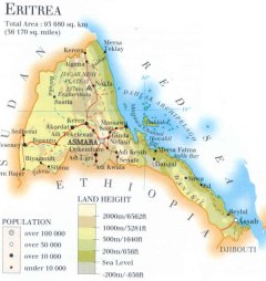
| location: Northeast Africa |
| time zone: +3 UT |
| surface (land) area: 93679 sq.km = 36170 sq.mi //; - area incl. inland waters: sq.km = sq.mi |
| geographical position in extreme co-ordinates: North: 18° N / South: 12° N / East: 43° E / West: 36° E |
| borders (land): Sudan, Ethiopia, Djibouti |
| borders (coastline): Red Sea |
| climate: subtropical, influenced by altitude |
| Government |
| independent since: 1993-05-24 |
| type of government: republic |
| capital: Asmera (Asmara) |
| administrative division: region (6); formerly - until 1995 -: province (10) |
| Population |
| population according to the latest census (1984): 2703,998; or: 2748,304 |
| total population according to the estimate of midyear 2000: 4135,933; or: 4097,000 // - ; 2001: 3989,000 |
| population density: 44 per sq.km = 113 per sq.mi |
| population growth: 2,7% //; - doubling time: 25 years ; although recently the population tends to decline |
| birth rate: 44 per 1000 |
| death rate: 12 - 16 per 1000 |
| fertility rate: 6,5 children per female |
| maternal mortality: per 100,000 |
| infant mortality (1-4 years): 120 per 1000 |
| life expectancy: 56 years (male: 54; female: 59) |
| age breakdown: 0-14 years: 46% //; - 15-59 years: 48% //; - 60+ years: 6% |
| urbanisation: 19% //; - urbanisation growth: % |
| percentage of urban population in the greatest city: % |
| Ethnic composition, language, religion |
| ethnic groups: Tigrinya 49%; Tigre 32%; Afar 4%; Hedareb 4%; Kunama 3% |
| languages: Tirginya, Tigre, Afar, Arabic, Bilen, Kunama, Nara, Saho, Hadareb, Amharic, Italian |
| religious affiliation: Muslim 69%; Coptic Christian 31%; other (incl. Animist, Roman Catholic, Protestant) |
| Health |
| daily food intake: calories per capita |
| population with access to safe water: 46% |
| people per physician: 48000 |
| people per hospital bed: |
| Education, literacy |
| school enrolment: primary education 6-11 years: % |
| school enrolment: secondary education: % |
| school enrolment: tertiary education 20-24 years: % |
| adult literacy: ca 55% (male: %; female: %) |
| Economy and infrastructure |
| Economy and trade |
| currency: Nakfa = 100 centesimi |
| annual inflation rate: 9% |
| population below poverty line: 53% |
| Gross Domestic Product: USD 120 per capita |
| GNI USD 170 per capita //; - [ppp: 960] |
| GDP growth: 1% |
| income: USD per capita |
| import: USD 423 per capita //; - export: USD 86 per capita |
| trade: USD 104 per capita //; - or % of GDP |
| trade partners: IT ET SA SD |
| human development index: 0,416 //; - position of the country in the world no.: 148 |
| female labour force: 47% |
| unemployment: % |
| tourism: 0,07 million |
| Economic activities in agriculture, fisheries, industry, mining, services, energy |
| land use: arable land: % //; - grass land: % //; - wooded area: 16% //; - arid land and desert: % |
| agriculture: labour force: 80% //; - part of agriculture in GDP: 11 - 17% |
| agricultural products: cereals, roots & tubers, sorghum, lentils, pulses, vegetables, melons, millet, barley, cotton, coffee, tobacco |
| livestock (million): camels: 0,08 / cattle: 2,2 / goats: 1,7 / poultry: 1,2 / sheep: 1,6 |
| fish catch: 7042 metric tonnes |
| industry: labour force: % //; - part of industry in GDP: 17% |
| industrial products: food processing, textiles, beverages (all of small importance) |
| mining products: copper, potash, gold, iron, silver, zinc, oil, silica, granite, marble, salt |
| CO2 emission per capita: |
| services: labour force: % //; - part of services in GDP: 58% |
| energy use (kg per capita): |
| electricity use (per capita): |
| annual water use (per capita): |
| Traffic, communication |
| road network: 3930 - 4010 km //; - of which paved: 21% //; - of which are motorways: 0 km |
| vehicles: 1,5 per 1000 |
| railways: 117 km, but not operating //; - railways passenger/km: - |
| navigable inland waterways: 0 km |
| ownership telephone: 5 - 7 per 1000 |
| ownership radio receivers: 91 per 1000 |
| ownership tv-sets: 6 - 16 per 1000 |
| newspaper circulation: per 1000 |
| persons per post office: 95300 |
| personal computers: 1,6 per 1000 |
| Some physical landmarks |
| mountains: Soira 2989 m, Ira 2817, Suara 2603, Fangaga 2589, Enghershatu 2576 |
| lowest point: sea level |
| lakes (natural): unknown |
| lakes (artificial reservoirs): unknown |
| lakes (deepest): unknown |
| rivers: Baraka, Falkat, Ansebu, Gash, Tekeze |
| canals: none |
| waterfalls: unknown |
| caves: longest system: unknown / deepest: |
| islands: Dahlak archipelago |
| deserts: Danakil |
| other natural features: |
| Additional remarks, especially on the statistical information |
| other important features: |
| apart from physical landmarks most of the above figures are changeable, in most cases they date from the 1990's |
| most available sources at the disposal of the compiler state much figures combined with those of Ethiopia |
| primary sources used for the general information: |
| BB CA EV PW WA WB WR, and some national statistical yearbooks |
| particulars concerning population data: |
| Eritrea is a relative young state; it does not publish much statistical data yet |
 To the page containing the population growth statistics of the country
 To the page containing the historical population growth statistics of the provinces
 To the page containing urban historical population statistics
 Back to the homepage of this website: POPULATION STATISTICS
Internet website:Latest modification of this page on 2004-02-08 by Jan Lahmeyer
© "populstat" site: Jan Lahmeyer