All countries of the world listed from A-Z:

or choose from the countries per continent below:


 |  |  |  |  |  |
 | NIUEgeneral data of the country |
| General useful information |
| Note: some data are of constant value, while other are due to changes, fluctuations etc. |
| Nation and population |
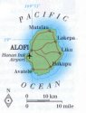
| official name (short form): Niue |
| country code ISO: NU //; - FIPS: NE |
| location: Western Pacific |
| time zone: -11 UT |
| surface (land) area: 258 sq.km = 100 sq.mi //; - area incl. inland waters: sq.km = sq.mi |
| geographical position in extreme co-ordinates: North/South: 19° S / East/West: 170° W |
| borders (land): none |
| borders (coastline): Pacific Ocean |
| climate: tropical oceanic |
| Government |
| independent since: not yet |
| type of government: territory in free association with New Zealand |
| capital: Alofi |
| administrative division: unknown |
| Population |
| population according to the latest census (1997): 2,088 |
| total population according to the estimate of midyear 2000: 2,113 /-; 2001: 2,000 |
| population density: 8 per sq.km = 21 per sq.mi |
| population growth: -?% [declining] //; - doubling time: not applicable, population is stable or declining |
| birth rate: 17 per 1000 |
| death rate: 5 per 1000 |
| fertility rate: children per female |
| maternal mortality: per 100,000 |
| infant mortality (1-4 years): per 1000 |
| life expectancy: 62,5 years (male: 60; female: 65) |
| age breakdown: 0-14 years: % //; - 15-59 years: % //; - 60+ years: % |
| urbanisation: 71% //; - urbanisation growth: % |
| percentage of urban population in the greatest city: % |
| Ethnic composition, language, religion |
| ethnic groups: Niueans, Tongans, Europeans (mainly New Zealanders), Samoans, Asians |
| languages: English, Niuean |
| religious affiliation: Congregational (Ekalesia Niue) 75%; Mormons 10%; Roman Catholic 5% |
| Health |
| daily food intake: calories per capita |
| population with access to safe water: % |
| people per physician: 700 |
| people per hospital bed: |
| Education, literacy |
| school enrolment: primary education 6-11 years: % |
| school enrolment: secondary education: % |
| school enrolment: tertiary education 20-24 years: % |
| adult literacy: % (male: %; female: %) |
| Economy and infrastructure |
| Economy and trade |
| currency: New Zealand dollar = 100 cents |
| annual inflation rate: % |
| population below poverty line: % |
| Gross Domestic Product: USD per capita |
| GNI USD per capita //; - [ppp: ] |
| GDP growth: % |
| income: USD per capita |
| import: USD per capita //; - export: USD per capita |
| trade: USD per capita //; - or % of GDP |
| trade partners: NZ AU |
| human development index: //; - position of the country in the world no.: |
| female labour force: % |
| unemployment: % |
| tourism: 0,002 million |
| Economic activities in agriculture, fisheries, industry, mining, services, energy |
| land use: arable land: % //; - grass land: % //; - wooded area: % //; - arid land and desert: % |
| agriculture: labour force: 6% //; - part of agriculture in GDP: % |
| agricultural products: tropical fruits, coconuts, copra, honey, limes and root crops (taros, yams) |
| livestock (1000s): asses: / cattle: / goats: / horses: / pigs: 2 / poultry: 10 / sheep: |
| fish catch: 120 metric tonnes |
| industry: labour force: 9% //; - part of industry in GDP: % |
| industrial products: timber |
| mining products: none |
| CO2 emission per capita: |
| services: labour force: 80% //; - part of services in GDP: % |
| energy use (kg per capita): |
| electricity use (per capita): |
| annual water use (per capita): |
| Traffic, communication |
| road network: ? km //; - of which paved: % //; - of which are motorways: km |
| vehicles: 330 per 1000 |
| railways: 0 km //; - railways passenger/km: - |
| navigable inland waterways: 0 km |
| ownership telephone: 250 per 1000 |
| ownership radio receivers: per 1000 |
| ownership tv-sets: per 1000 |
| newspaper circulation: per 1000 |
| persons per post office: |
| personal computers: per 1000 |
| Some physical landmarks |
| mountains: Liha Point 223 m |
| lowest point: sea level |
| lakes (natural): the inner lake of the coral island itself |
| lakes (artificial reservoirs): none |
| lakes (deepest): none |
| rivers: none |
| canals: none |
| waterfalls: none |
| caves: longest system: none / deepest: |
| islands: except for Niue there are two isolated reefs: Antiope and Beveridge |
| deserts: none |
| other natural features: Niue is the world largest coral island |
| Additional remarks, especially on the statistical information |
| other important features: |
| apart from physical landmarks most of the above figures are changeable, in most cases they date from the 1990's |
| the name Niue is derived from Niuean, meaning: "There are coconuts " (source GL) / former name: Savage Island |
| primary sources used for the general information: |
| BB CA EV PW WA WB WR, and some national statistical yearbooks / data are often combined with those of New Zealand |
| particulars concerning population data: |
| some 15,000 Niueans have emigrated to New Zealand |
 To the page containing the population growth statistics of the country
 To the page containing urban historical population statistics
 Back to the homepage of this website: POPULATION STATISTICS
Internet website:Since this is a tiny country there are no data of an administrative division available.
Latest modification of this page on 2004-02-29 by Jan Lahmeyer
© "populstat" site: Jan Lahmeyer