All countries of the world listed from A-Z:

or choose from the countries per continent below:


 |  |  |  |  |  |
 | GUAMgeneral data of the country |
| General useful information |
| Note: some data are of constant value, while other are due to changes, fluctuations etc. |
| Nation and population |
| official name (short form): Guam |
| country code ISO: GU //; - FIPS: GQ |
| location: Western Pacific Ocean |
| time zone: +10 UT |
| surface (land) area: 541 sq.km = 209 sq.mi //; - area incl. inland waters: sq.km = sq.mi |
| geographical position in extreme co-ordinates: North/South: 13° N / East/West: 145° E |
| borders (land): none |
| borders (coastline): Pacific Ocean |
| climate: tropical |
| Government |
| independent since: not yet |
| type of government: self-governing unincorporated territory of the USA |
| capital: Hagatña (Agaña) |
| administrative division: district (19) |
| Population |
| population according to the latest census (1990): 133,152 |
| total population according to the estimate of midyear 2000: 154,623 // - ; 2001: 158,000 |
| population density: per 292 sq.km = 756 per sq.mi |
| population growth: 2,3 //; - doubling time: ca 40 years |
| birth rate: 27 per 1000 |
| death rate: 4 per 1000 |
| fertility rate: 3 children per female |
| maternal mortality: per 100,000 |
| infant mortality (1-4 years): 12 per 1000 |
| life expectancy: 72 years (male: 70; female: 75) |
| age breakdown: 0-14 years: 30% //; - 15-59 years: 63% //; - 60+ years: 7% |
| urbanisation: 38% //; - urbanisation growth: % |
| percentage of urban population in the greatest city: % |
| Ethnic composition, language, religion |
| ethnic groups: Chamorro 47%; Filipino 25%; US military personnel ca 20% |
| languages: English, Chamorro, Japanese |
| religious affiliation: Roman Catholic 80 - 98% |
| Health |
| daily food intake: calories per capita |
| population with access to safe water: % |
| people per physician: |
| people per hospital bed: |
| Education, literacy |
| school enrolment: primary education 6-11 years: % |
| school enrolment: secondary education: % |
| school enrolment: tertiary education 20-24 years: % |
| adult literacy: 96% (male: %; female: %) |
| Economy and infrastructure |
| Economy and trade |
| currency: US dollar = 100 cents |
| annual inflation rate: % |
| population below poverty line: % |
| Gross Domestic Product: USD per capita |
| GNI USD per capita //; - [ppp: ] |
| GDP growth: % |
| income: USD 19000 per capita |
| import: USD 611 per capita //; - export: USD 39 per capita |
| trade: USD 5000 per capita //; - or % of GDP |
| trade partners: US |
| human development index: //; - position of the country in the world no.: |
| female labour force: 37% |
| unemployment: 7% |
| tourism: 1,3 million |
| Economic activities in agriculture, fisheries, industry, mining, services, energy |
| land use: arable land: 22% //; - grass land: 15% //; - wooded area: 18 - 38% //; - arid land and desert: % |
| agriculture: labour force: % //; - part of agriculture in GDP: % |
| agricultural products: tobacco, copra, cabbages, eggplants, cucumber, long beans, tomatoes, bananas, coconuts, watermelon > |
| livestock (1000s): pigs: 3 / poultry: 11 // some more agricultural products: yams, cantaloupe, papayas, maize, sweet potatoes |
| fish catch: 223 metric tonnes |
| industry: labour force: % //; - part of industry in GDP: % |
| industrial products: textiles, beverages, construction, foods, printing & publishing |
| mining products: none |
| CO2 emission per capita: 27,6 |
| services: labour force: 85% //; - part of services in GDP: % |
| energy use (kg per capita): 9429 |
| electricity use (per capita): |
| annual water use (per capita): |
| Traffic, communication |
| road network: 885 km //; - of which paved: 76% //; - of which are motorways: 0 km |
| vehicles: 677 per 1000 |
| railways: 0 km //; - railways passenger/km: - |
| navigable inland waterways: 0 km |
| ownership telephone: 461 per 1000 |
| ownership radio receivers: 1827 per 1000 |
| ownership tv-sets: 648 per 1000 |
| newspaper circulation: 170 per 1000 |
| persons per post office: |
| personal computers: per 1000 |
| Some physical landmarks |
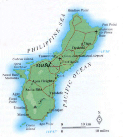
| mountains: Mt. Lamlam 406 m, Mt. Sasalaguan 337, Mt. Tenjo 313, Mt. Santa Rosa 252 |
| lowest point: sea level |
| lakes (natural): none; or: unknown |
| lakes (artificial reservoirs): Fena Valle Reservoir |
| lakes (deepest): unknown |
| rivers: Pago, Ugum |
| canals: none; or: unknown |
| waterfalls: none; or: unknown |
| caves: longest system: none; or: unknown / deepest: |
| islands: Cabras Island, Cocos Island, Bangi Island |
| deserts: none |
| other natural features: |
| Additional remarks, especially on the statistical information |
| other important features: |
| apart from physical landmarks most of the above figures are changeable, in most cases they date from the 1990's |
| nick name(s): Where America's day begins // song: Stand ye Guamanians |
| flower: Puti Tai Nobio (Bougainvillea) // bird: Toto (Fruit dove) // tree: Ifit (Intsiabijuga) |
| primary sources used for the general information: |
| BB CA EV PW WA WB WR, and some national statistical yearbooks |
| particulars concerning population data: none; or: unknown |
 To the page containing the population growth statistics of the country
 To the page containing data of the administrative division in districts
To the page containing urban historical population statistics
 Back to the homepage of this website: POPULATION STATISTICS
Latest modification of this page on 2004-02-15 by Jan Lahmeyer
© "populstat" site: Jan Lahmeyer