All countries of the world listed from A-Z:

or choose from the countries per continent below:


 |  |  |  |  |  |
 | FRENCH POLYNESIA[Polynésie française] : |
| General useful information |
| Note: some data are of constant value, while other are due to changes, fluctuations etc. |
| Nation and population |
| official name (short form): Polynésie française |
| country code ISO: PF //; - FIPS: FP |
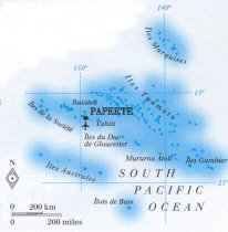
| location: South Pacific Ocean |
| time zone: -10 UT |
| surface (land) area: 3521 sq.km = 1359 sq.mi //; - area incl. inland waters: 4167 sq.km = 1609 sq.mi |
| geographical position in extreme co-ordinates: North: 5° S / South: 30° S / East: 132° W / West: 156° W |
| borders (land): none |
| borders (coastline): Pacific Ocean |
| climate: tropical |
| Government |
| independent since: not yet |
| type of government: overseas territory of France since 1958 |
| capital: Papeete |
| administrative division: circonscription (5) |
| Population |
| population according to the latest census (1996): 219,521 |
| total population according to the estimate of midyear 2000: 249,110; and 2001: 235,000 |
| population density: 67 per sq.km = 173 per sq.mi |
| population growth: 2% //; - doubling time: years |
| birth rate: 28 per 1000 |
| death rate: 5 per 1000 |
| fertility rate: 3 children per female |
| maternal mortality: per 100,000 |
| infant mortality (1-4 years): 22 per 1000 |
| life expectancy: 71 years (male: 69; female: 74) |
| age breakdown: 0-14 years: 36% //; - 15-59 years: 59% //; - 60+ years: 5% |
| urbanisation: 65% //; - urbanisation growth: % |
| percentage of urban population in the greatest city: 100% |
| Ethnic composition, language, religion |
| ethnic groups: Polynesian 69%; French and other Europeans 12%; Chinese 5%; other 15% |
| languages: French, Tahitian |
| religious affiliation: Protestant 47 - 54%; Roman Catholic 30 - 37% [differences depend on sources used] |
| Health |
| daily food intake: calories per capita |
| population with access to safe water: 100% |
| people per physician: 596 |
| people per hospital bed: 224 |
| Education, literacy |
| school enrolment: primary education 6-11 years: 100% |
| school enrolment: secondary education: % |
| school enrolment: tertiary education 20-24 years: % |
| adult literacy: 98% (male: %; female: %) |
| Economy and infrastructure |
| Economy and trade |
| currency: CFP franc = 100 centimes |
| annual inflation rate: 1,2% |
| population below poverty line: % |
| Gross Domestic Product: USD per capita |
| GNI USD 17920 per capita //; - [ppp: 23340] |
| GDP growth: 0,1% |
| income: USD 6000 per capita |
| import: USD 881 per capita //; - export: USD 226 per capita |
| trade: USD 4500 per capita //; - or 38% of GDP |
| trade partners: FR |
| human development index: //; - position of the country in the world no.: |
| female labour force: 37% |
| unemployment: % |
| tourism: 0,2 million |
| Economic activities in agriculture, fisheries, industry, mining, services, energy |
| land use: arable land: 7% //; - grass land: 5% //; - wooded area: 31% //; - arid land and desert: % |
| agriculture: labour force: 10% //; - part of agriculture in GDP: 5% |
| agricultural products: vanilla, citrus fruits, roots & tubers, melons, pineapples, coconuts, cassava, copra |
| livestock (1000s): cattle: 10 / goats: 16 / horses: 2 / pigs: 37 / poultry: 100 / sheep: 2 |
| fish catch: 12336 metric tonnes |
| industry: labour force: 7% //; - part of industry in GDP: 15% |
| industrial products: cultured pearls |
| mining products: of no importance |
| CO2 emission per capita: 2,5 |
| services: labour force: 83% //; - part of services in GDP: 80% |
| energy use (kg per capita): 1400 |
| electricity use (per capita): |
| annual water use (per capita): |
| Traffic, communication |
| road network: 884 - 940 km //; - of which paved: 42% //; - of which are motorways: 0 km |
| vehicles: 277 per 1000 |
| railways: 0 km //; - railways passenger/km: - |
| navigable inland waterways: 0 km |
| ownership telephone: 225 per 1000 |
| ownership radio receivers: 488 per 1000 |
| ownership tv-sets: 178 per 1000 |
| newspaper circulation: 112 per 1000 |
| persons per post office: 2250 |
| personal computers: per 1000 |
| Some physical landmarks |
| mountains: Mt. Orohena 2241 m, Mt. Aorai 2066, Mt. Tetufera 1799 |
| lowest point: sea level |
| lakes (natural): Lac Vaihiria |
| lakes (artificial reservoirs): none |
| lakes (deepest): unknown |
| rivers: there are only some small rivers to drain water from the mountains |
| canals: none |
| waterfalls: unknown |
| caves: longest system: unknown / deepest: |
| islands: Îles de la Société: 14 islands; Tuamotu: 76; Marquesas: 13; Gambier: 9; îles Australes: 9 |
| deserts: none |
| other natural features: |
| Additional remarks, especially on the statistical information |
| other important features: |
| apart from physical landmarks most of the above figures are changeable, in most cases they date from the 1990's |
| primary sources used for the general information: |
| BB CA EV PW WA WB WR, and some national statistical yearbooks |
| particulars concerning population data: |
 To the page containing the population growth statistics of the country
 To the page containing the historical population growth statistics of the provinces
 To the page containing urban historical population statistics
 Back to the homepage of this website: POPULATION STATISTICS
Internet website: For more figures of FranceLatest modification of this page on 2004-02-12 by Jan Lahmeyer
© "populstat" site: Jan Lahmeyer