All countries of the world listed from A-Z:

or choose from the countries per continent below:


 |  |  |  |  |  |
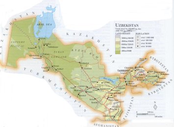 | UZBEKISTAN[Uzbekiston] : |
| General useful information |
| Note: some data are of constant value, while other are due to changes, fluctuations etc. |
| Nation and population |
| official name (short form): Ûzbekiston |
| country code ISO: UZ //; - FIPS: UZ |
| location: Central Asia |
| time zone: +5 UT |
| surface (land) area: 447400 sq.km = 172700 sq.mi //; - area incl. inland waters: sq.km = sq.mi |
| geographical position in extreme co-ordinates: North: 46° N / South: 37° N / East: 73° E / West: 56° E |
| borders (land): Kazakhstan, Kyrgyzstan, Tajikistan, Afghanistan, Turkmenistan |
| borders (coastline): none |
| climate: harsh continental |
| Government |
| independent since: 1991-08-31 |
| type of government: republic |
| capital: To`'skent (Tashkent) |
| administrative division: wiloyat (12) + autonomous republic (1) |
| Population |
| population according to the latest census (1989): 19810,077; or: 19905,158 |
| total population according to the estimate of midyear 2000: 24755,519; or: 24752,000 /-; 2001: 24731,000; or: 25155,064 |
| population density: 55 per sq.km = 143 per sq.mi |
| population growth: 2% //; - doubling time: 30 years |
| birth rate: 26 - 29 per 1000 |
| death rate: 6,6 - 8 per 1000 |
| fertility rate: 4 children per female |
| maternal mortality: per 100,000 |
| infant mortality (1-4 years): 26 per 1000 |
| life expectancy: 65 - 70 years (male: 60 - 66; female: 68 - 72) |
| age breakdown: 0-14 years: 42% //; - 15-59 years: 53% //; - 60+ years: 5% |
| urbanisation: 37% //; - urbanisation growth: % |
| percentage of urban population in the greatest city: % |
| Ethnic composition, language, religion |
| ethnic groups: Uzbek 75,8%; Russian 6%; Tajik 4,8%; Kazakh 4,1%; Karakalpak 2,1%; Tatar 1,6%; Kyrgyz 0,9%; > |
| languages: Uzbek (official); Russian // more ethnic groups: Korean 0,9%; Ukrainian 0,6%; Turkmen 0,6%; other 2,5% |
| religious affiliation: Sunnî Muslim (Hanafiyah) 88%; Russian Orthodox 1%; other 1%; non-religious 10% |
| Health |
| daily food intake: calories per capita |
| population with access to safe water: 57 - 85% |
| people per physician: 302 |
| people per hospital bed: 118 |
| Education, literacy |
| school enrolment: primary education 6-11 years: 99% |
| school enrolment: secondary education: 58% |
| school enrolment: tertiary education 20-24 years: 9% |
| adult literacy: 97% (male: 98%; female: 96%) [total in source CA: 89%] |
| Economy and infrastructure |
| Economy and trade |
| currency: som, or sum (plural: sumy) = 100 teen |
| annual inflation rate: 247% |
| population below poverty line: % |
| Gross Domestic Product: USD 2529 per capita |
| GNI USD 360 per capita //; - [ppp: 2360] |
| GDP growth: -2,4% |
| income: USD 1350 per capita |
| import: USD 2839 per capita //; - export: USD 3109 per capita |
| trade: USD 250 per capita //; - or 76% of GDP |
| trade partners: mainly CIS-countries: RU KZ DE KR TJ TM KG |
| human development index: 0,698 //; - position of the country in the world no.: 99 |
| female labour force: 47% |
| unemployment: 1% |
| tourism: 0,3 million |
| Economic activities in agriculture, fisheries, industry, mining, services, energy |
| land use: arable land: 10% //; - grass land: 46 - 53% //; - wooded area: 3 - 4% //; - arid land and desert: ca 25 - 30% |
| agriculture: labour force: 29% //; - part of agriculture in GDP: 42% |
| agricultural products: seed cotton, vegetables, fruit, berries, grapes, potatoes, rice, barley, maize, rye |
| livestock (million): asses: 0,2 / camels: 0,03 / cattle: 5,2 / goats: 0,9 / horses: 0,2 / pigs: 0,08 / poultry: 15 / sheep: 8 |
| fish catch: 2871 metric tonnes |
| industry: labour force: 18% //; - part of industry in GDP: 40% |
| industrial products: textiles, machines, metals, processed foods, chemicals |
| mining products: copper, lead, gold, natural gas, coal, oil, uranium, tungsten, bauxite, silver |
| CO2 emission per capita: 4,5 |
| services: labour force: 53% //; - part of services in GDP: 18% |
| energy use (kg per capita): 2024 |
| electricity use (per capita): 1650 |
| annual water use (per capita): 4121 |
| Traffic, communication |
| road network: 78400, or 81600 km //; - of which paved: 87% //; - of which are motorways: 50 km |
| vehicles: 37 per 1000 |
| railways: 3380, or 3641 km //; - railways passenger/km: 5200 |
| navigable inland waterways: 1100 km |
| ownership telephone: 66 - 76 per 1000 |
| ownership radio receivers: 155 - 456 per 1000 |
| ownership tv-sets: 176 - 275 per 1000 |
| newspaper circulation: 7 per 1000 |
| persons per post office: |
| personal computers: per 1000 |
| Some physical landmarks |
| mountains: Manas 4488 m, Chod`'za Pirjach 4424, Adelung 4311, Be`'ster 4299, Agalytau 4218 |
| lowest point: 53 m, at the borders of the Aral Sea |
| lakes (natural): Aral Sea, Ozero Aydarkul' |
| lakes (artificial reservoirs): a few small ones |
| lakes (deepest): unknown |
| rivers: Amu (Amu Darya, Amudarjo) |
| canals: a few canals connecting some rivers and lakes, mainly for irrigation purposes |
| waterfalls: none, or unknown |
| caves: longest system: none, or unknown / deepest: |
| islands: none |
| deserts: Kyzyl Kum |
| other natural features: |
| Additional remarks, especially on the statistical information |
| other important features: |
| apart from physical landmarks most of the above figures are changeable, in most cases they date from the 1990's |
| primary sources used for the general information: |
| BB CA EV PW WA WB WR, and some national statistical yearbooks |
| particulars concerning population data: |
 To the page containing the population growth statistics of the country
 To the page containing the historical population growth statistics of the provinces
 To the page containing urban historical population statistics
 Back to the homepage of this website: POPULATION STATISTICS
Internet website:Latest modification of this page on 2004-03-13 by Jan Lahmeyer
© "populstat" site: Jan Lahmeyer