All countries of the world listed from A-Z:

or choose from the countries per continent below:


 |  |  |  |  |  |
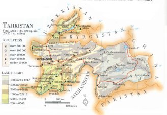 | TAJIKISTAN[Tadzjikiston] : |
| General useful information |
| Note: some data are of constant value, while other are due to changes, fluctuations etc. |
| Nation and population |
| official name (short form): Tojikistan |
| country code ISO: TJ //; - FIPS: TI |
| location: Central Asia |
| time zone: +5 UT |
| surface (land) area: 143100 sq.km = 55300 sq.mi //; - area incl. inland waters: sq.km = sq.mi |
| geographical position in extreme co-ordinates: North: 41° N / South: 37° N / East: 75° E / West: 67° E |
| borders (land): Kyrgyzstan, China, Afghanistan, Uzbekistan |
| borders (coastline): none |
| climate: continental, mountainous |
| Government |
| independent since: 1991-09-09 |
| type of government: republic |
| capital: Du`'sanbe |
| administrative division: viloyat (4) + viloyati avtonomii = autonomous republic (1) + city region (1) |
| Population |
| population according to the latest census (1989): 5108,576; or: 5092,603 |
| total population according to the estimate of midyear 2000: 6440,700; or: 6170,000/ -; 2001: 6578,651; or: 6237,000 |
| population density: 45 per sq.km = 117 per sq.mi |
| population growth: 2% //; - doubling time: 33 years |
| birth rate: 28 - 33 per 1000 |
| death rate: 7 - 8 per 1000 |
| fertility rate: 5 children per female |
| maternal mortality: per 100,000 |
| infant mortality (1-4 years): 40 per 1000 |
| life expectancy: 64 - 69 years (male: 61 - 66; female: 67 - 72) |
| age breakdown: 0-14 years: 45% //; - 15-59 years: 49% //; - 60+ years: 6% |
| urbanisation: 28 - 33% //; - urbanisation growth: % |
| percentage of urban population in the greatest city: 35% |
| Ethnic composition, language, religion |
| ethnic groups: Tajik 63,8%; Uzbek 24%; Russian 6,5%; Tatar1,4%; Kyrgyz 1,3%; Ukrainian 0,7%; German 0,3%; other 2% |
| languages: Tajik (official); Russian |
| religious affiliation: predominantly Sunnî Muslim 80%; Shî'î Muslim 5%; also some Christian 1%; non-religious 14% |
| Health |
| daily food intake: 2176 calories per capita |
| population with access to safe water: 69% |
| people per physician: 265 |
| people per hospital bed: |
| Education, literacy |
| school enrolment: primary education 6-11 years: 85% |
| school enrolment: secondary education: 55% |
| school enrolment: tertiary education 20-24 years: 8% |
| adult literacy: 98% (male: 99%; female: 97%) |
| Economy and infrastructure |
| Economy and trade |
| currency: Somoni = 100 diram |
| annual inflation rate: 235% |
| population below poverty line: % |
| Gross Domestic Product: USD 350 per capita |
| GNI USD 180 per capita //; - [ppp: 1090] |
| GDP growth: -12% |
| income: USD 1050 per capita |
| import: USD 799 per capita //; - export: USD 749 per capita |
| trade: USD 400 per capita //; - or 147% of GDP |
| trade partners: CIS-countries |
| human development index: 0,66 //; - position of the country in the world no.: 103 |
| female labour force: 45% |
| unemployment: 3% |
| tourism: 0,5 million |
| Economic activities in agriculture, fisheries, industry, mining, services, energy |
| land use: arable land: 6% //; - grass land: 25% //; - wooded area: 4% //; - arid land and desert: % |
| agriculture: labour force: 43% //; - part of agriculture in GDP: 37% |
| agricultural products: vegetables, seed cotton, fruit, wheat, potatoes, grapes, barley, maize, rice |
| livestock (million): cattle: 1 / goats: 0,6 / pigs: 0,002 / poultry: 1 / sheep: 2 |
| fish catch: 200 metric tonnes |
| industry: labour force: 14% //; - part of industry in GDP: 42% |
| industrial products: metals, textiles, food processing, machinery, chemicals, construction materials, aluminium, cement |
| mining products: uranium, gold, iron, lead, mercury, tin, gypsum, bauxite, antimony, natural oil, coal, zinc |
| CO2 emission per capita: 0,8 |
| services: labour force: 44% //; - part of services in GDP: 21% |
| energy use (kg per capita): 543 |
| electricity use (per capita): 2163 |
| annual water use (per capita): 2455 |
| Traffic, communication |
| road network: 13700, or 28500 km //; - of which paved: 83% //; - of which are motorways: 0 km |
| vehicles: 29 per 1000 |
| railways: 480, or 547 km //; - railways passenger/km: 9808 |
| navigable inland waterways: 200 km |
| ownership telephone: 35 - 45 per 1000 |
| ownership radio receivers: 150 per 1000 |
| ownership tv-sets: 258 - 285 per 1000 |
| newspaper circulation: 13 per 1000 |
| persons per post office: 7930 |
| personal computers: per 1000 |
| Some physical landmarks |
| mountains: Independence Peak (Garmo) 7495 [7134] m, Peak Abu Aali Ibn Sina 6974 [6940], [nameless peak] 6852, Qatorkuhi Akademiyay Fanho 6785 |
| lowest point: ca 180 m, at the Southwestern tip of the country where the Amu Darya leaves the country |
| lakes (natural): Qarokûl |
| lakes (artificial reservoirs): Qayroqqum (Kayrakkum) |
| lakes (deepest): unknown |
| rivers: Amu Darya, Zaraf`'son (Zeravshan), Vach`'s (Vakhsh), Pjand`'z (Panj, Pyandzh), Bartang |
| canals: none, or unknown |
| waterfalls: none, or unknown |
| caves: longest system: none, or unknown / deepest: unknown |
| islands: none |
| deserts: none |
| other natural features: unknown |
| Additional remarks, especially on the statistical information |
| other important features: |
| apart from physical landmarks most of the above figures are changeable, in most cases they date from the 1990's |
| Names of mountains "Independence Peak" and "Abu Ali Ibn Sina" were before 2006: "Pik Kommunizma" and "Peak Revoljuitsii" |
| primary sources used for the general information: |
| BB CA EV PW WA WB WR, and some national statistical yearbooks |
| particulars concerning population data: |
 To the page containing the population growth statistics of the country
 To the page containing the historical population growth statistics of the provinces
 To the page containing urban historical population statistics
 Back to the homepage of this website: POPULATION STATISTICS
Internet website: Internet website:Latest modification of this page on 2006-07-03 by Jan Lahmeyer
© "Populstat" website: Jan Lahmeyer