All countries of the world listed from A-Z:

or choose from the countries per continent below:


 |  |  |  |  |  |
 | QATAR[Katar] : |
| General useful information |
| Note: some data are of constant value, while other are due to changes, fluctuations etc. |
| Nation and population |
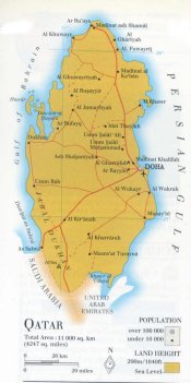
| official name (short form): Qatar |
| country code ISO: QA //; - FIPS: QA |
| location: Southwest Asia, Middle East |
| time zone: +3 UT |
| surface (land) area: 11437 sq.km = 4416 sq.mi //; - area incl. inland waters: sq.km = sq.mi |
| geographical position in extreme co-ordinates: North: 26° N / South: 24° N / East: 52° E / West: 51° E |
| borders (land): Saudi Arabia, United Arab Emirates |
| borders (coastline): Persian Gulf (part of Indian Ocean) |
| climate: hot and humid, semi-arid tropical |
| Government |
| independent since: 1971-09-03 |
| type of government: absolute traditional monarchy (emirate) |
| capital: Ad-Dawhah (Doha) |
| administrative division: balafiyah = municipality (9) |
| Population |
| population according to the last two censuses (1986): 369,079 /-; (1997) 522,023 |
| total population according to the estimate of midyear 2000: 585,000, or: 744,483 /-; 2001: 574,000, or: 769,152 |
| population density: 51 - 65 per sq.km = 132 - 169 per sq.mi |
| population growth: 1,6 - 6,4% //; - doubling time: 44 years |
| birth rate: 16 - 18 per 1000 |
| death rate: 2 - 4 per 1000 |
| fertility rate: 6 children per female |
| maternal mortality: per 100,000 |
| infant mortality (1-4 years): 18 per 1000 |
| life expectancy: 72 years (male: 70; female: 75) |
| age breakdown: 0-14 years: 35% //; - 15-59 years: 62% //; - 60+ years: 4% |
| urbanisation: 92,5% //; - urbanisation growth: % |
| percentage of urban population in the greatest city: % |
| Ethnic composition, language, religion |
| ethnic groups: Arab (Qatari) 40 - 56%; Southern Asian 50% (Pakistani 7 - 18%; Indians 18% and Iranians 10 - 23%) |
| languages: Arabic (official); English |
| religious affiliation: Sunnî Muslim 92%, Christian, Hindu |
| Health |
| daily food intake: calories per capita |
| population with access to safe water: 100% |
| people per physician: 793 |
| people per hospital bed: |
| Education, literacy |
| school enrolment: primary education 6-11 years: % |
| school enrolment: secondary education: % |
| school enrolment: tertiary education 20-24 years: % |
| adult literacy: 81% (male: %; female: %) |
| Economy and infrastructure |
| Economy and trade |
| currency: Qatar riyal = 100 dirhams |
| annual inflation rate: 2% |
| population below poverty line: % |
| Gross Domestic Product: USD 21000 per capita |
| GNI USD per capita //; - [ppp: 11570] |
| GDP growth: 4% |
| income: USD 16000 per capita |
| import: USD 1927 per capita //; - export: USD 3213 per capita |
| trade: USD 28300 per capita //; - or 88% of GDP |
| trade partners: JP GB IT DE UA SG BR AU CA CN FR IN IT KR MY NL SA ES SE US |
| human development index: 0,801 //; - position of the country in the world no.: 48 |
| female labour force: 15% |
| unemployment: % |
| tourism: 0,5 million |
| Economic activities in agriculture, fisheries, industry, mining, services, energy |
| land use: arable land: 0,7% //; - grass land: 4,5% //; - wooded area: 0% //; - arid land and desert: 94,7% |
| agriculture: labour force: 3% //; - part of agriculture in GDP: 2% |
| agricultural products: milk and dairy products, forage, vegetables, fruits and dates |
| livestock (1000s): camels: 50 / cattle: 14 / goats: 160-179 / poultry: 3850-4000 / sheep: 200-215 |
| fish catch: metric tonnes |
| industry: labour force: 28% //; - part of industry in GDP: 39% |
| industrial products: (petro)chemicals, metal products, textiles, food & beverages, tobacco, oil refining |
| mining products: oil & natural gas, limestone, sulphur |
| CO2 emission per capita: 85,7 |
| services: labour force: 69% //; - part of services in GDP: 59% |
| energy use (kg per capita): 28262 |
| electricity use (per capita): 14871 |
| annual water use (per capita): |
| Traffic, communication |
| road network: 1230, or 1500 km //; - of which paved: 90% //; - of which are motorways: 0 km |
| vehicles: 226 per 1000 |
| railways: 0 km //; - railways passenger/km: - |
| navigable inland waterways: 0 km |
| ownership telephone: 212 - 263 per 1000 |
| ownership radio receivers: 311 - 490 per 1000 |
| ownership tv-sets: 440 - 514 per 1000 |
| newspaper circulation: 138 per 1000 |
| persons per post office: 18600 |
| personal computers: 150 per 1000 |
| Some physical landmarks |
| mountains: Qurayn Abâ al-Bawl 105 m |
| lowest point: sea level |
| lakes (natural): none |
| lakes (artificial reservoirs): none |
| lakes (deepest): not applicable |
| rivers: none |
| canals: none |
| waterfalls: none |
| caves: longest system: none / deepest: |
| islands: Huwâr |
| deserts: at the edge of the Arab desert |
| other natural features: |
| Additional remarks, especially on the statistical information |
| other important features: |
| apart from physical landmarks most of the above figures are changeable, in most cases they date from the 1990's |
| primary sources used for the general information: |
| BB CA EV PW WA WB WR, and some national statistical yearbooks |
| particulars concerning population data: |
 To the page containing the population growth statistics of the country
 To the page containing urban historical population statistics
 Back to the homepage of this website: POPULATION STATISTICS
Internet website:Latest modification of this page on 2004-03-03 by Jan Lahmeyer
© "populstat" site: Jan Lahmeyer