All countries of the world listed from A-Z:

or choose from the countries per continent below:


 |  |  |  |  |  |
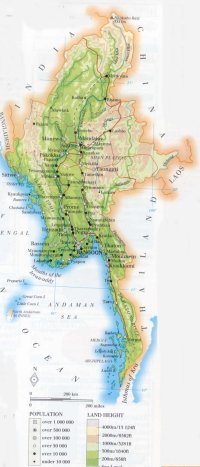 | MYANMAR[Birma ; Burma] : |
| General useful information |
| Note: some data are of constant value, while other are due to changes, fluctuations etc. |
| Nation and population |
| official name (short form): Myanmar |
| country code ISO: MM //; - FIPS: BM |
| location: Southeast Asia |
| time zone: + 6:30 UT |
| surface (land) area: 676550 sq.km = 261216 sq.mi //; - area incl. inland waters: sq.km = sq.mi |
| geographical position in extreme co-ordinates: North: 28° N / South: 10° N / East: 101° E / West: 92° E |
| borders (land): Bangladesh, India, China, Laos, Thailand |
| borders (coastline): Indian Ocean |
| climate: tropical monsoon |
| Government |
| independent since: 1948-01-04 |
| type of government: republic |
| capital: Yangon (Rangoon) |
| administrative division: division (7) + state (7) |
| Population |
| population according to the latest census (1983): 35307,913 |
| total population according to the estimate of midyear 2000: 41734,854; or: 47749,000 / -; 2001: 45976,000 |
| population density: 68 per sq.km = 176 per sq.mi |
| population growth: 1,7% //; - doubling time: ca 50 years |
| birth rate: 20 -30 per 1000 |
| death rate: 9 - 12 per 1000 |
| fertility rate: 4 children per female |
| maternal mortality: 140 per 100,000 |
| infant mortality (1-4 years): 70 per 1000 |
| life expectancy: 56 years (male: 54; female: 57) |
| age breakdown: 0-14 years: 37% //; - 15-59 years: 56% //; - 60+ years: 6% |
| urbanisation: 27% //; - urbanisation growth: % |
| percentage of urban population in the greatest city: % |
| Ethnic composition, language, religion |
| ethnic groups: Burman 69%; Shan 8,5%; Karen 6,2%; Rakhine 4,5%; Mon 2,4%; Chin 2,2%; Kachin 1,4%; other 5,8% |
| languages: Burmese (official); English |
| religious affiliation: Buddhist 89%; Christian 5%; Muslim 4%; Animist 1%; Hindu 0,5% |
| Health |
| daily food intake: 2832 calories per capita |
| population with access to safe water: 38% |
| people per physician: 3700 |
| people per hospital bed: |
| Education, literacy |
| school enrolment: primary education 6-11 years: 100% |
| school enrolment: secondary education: 24% |
| school enrolment: tertiary education 20-24 years: 5% |
| adult literacy: 81 - 85% (male: %; female: %) |
| Economy and infrastructure |
| Economy and trade |
| currency: kyat = 100 pyas |
| annual inflation rate: 26% |
| population below poverty line: 28% |
| Gross Domestic Product: USD 863 per capita |
| GNI USD per capita //; - [ppp: ] |
| GDP growth: 5% |
| income: USD 500 per capita |
| import: USD 1419 per capita //; - export: USD 921 per capita |
| trade: USD 24 per capita //; - or % of GDP |
| trade partners: JP EU CH IN SG TH |
| human development index: 0,551 //; - position of the country in the world no.: 118 |
| female labour force: 43% |
| unemployment: 2% |
| tourism: 0,2 million |
| Economic activities in agriculture, fisheries, industry, mining, services, energy |
| land use: arable land: 15% //; - grass land: 1% //; - wooded area: 49% //; - arid land and desert: % |
| agriculture: labour force: 64% //; - part of agriculture in GDP: 51% |
| agricultural products: timber, cotton, groundnuts, rice, sugar cane, corn/maize, pulses |
| livestock (1000s): buffaloes: 2441 / cattle: 10964 / goats: 1392 / horses: 120 / pigs: 3914 / poultry: 43530 / sheep: 390 |
| fish catch: 851581 - 917666 metric tonnes |
| industry: labour force: 9% //; - part of industry in GDP: 12% |
| industrial products: forestry, mining, fishing, oil production, textiles, footwear, wood products, agric. processing |
| mining products: natural gas & oil, zinc, tungsten, nickel, lead, copper, tin, precious stones |
| CO2 emission per capita: 0,2 |
| services: labour force: 27% //; - part of services in GDP: 37% |
| energy use (kg per capita): 273 |
| electricity use (per capita): |
| annual water use (per capita): 101 |
| Traffic, communication |
| road network: 23463, or 28200 km //; - of which paved: 12% //; - of which are motorways: 0 km |
| vehicles: 2 per 1000 |
| railways: 3955, or 5060 km //; - railways passenger/km: 4894 |
| navigable inland waterways: 12800 km |
| ownership telephone: 3 -6 per 1000 |
| ownership radio receivers: 72 - 96 per 1000 |
| ownership tv-sets: 7 - 22 per 1000 |
| newspaper circulation: 23 per 1000 |
| persons per post office: 37400 |
| personal computers: 1 per 1000 |
| Some physical landmarks |
| mountains: Hkakabo Razi 5881 m, Hpunhpu 3480, Mt. Victoria 3053 |
| lowest point: sea level |
| lakes (natural): Indawgyi Lake, Inle Lake |
| lakes (artificial reservoirs): none, or unknown |
| lakes (deepest): unknown |
| rivers: Irrawaddy, Salween, Sittong |
| canals: none, or unknown |
| waterfalls: none, or unknown |
| caves: longest system: none, or unknown / deepest: |
| islands: Cheduba I., Boronga Island, Kadan Kyun, Kanmaw Kyun, Moscos Island |
| deserts: none |
| other natural features: |
| Additional remarks, especially on the statistical information |
| other important features: |
| apart from physical landmarks most of the above figures are changeable, in most cases they date from the 1990's |
| primary sources used for the general information: |
| BB CA EV PW WA WB WR, and some national statistical yearbooks |
| particulars concerning population data: |
 To the page containing the population growth statistics of the country
 To the page containing the historical population growth statistics of the provinces
 To the page containing urban historical population statistics
 Back to the homepage of this website: POPULATION STATISTICS
Internet website:Latest modification of this page on 2004-02-27 by Jan Lahmeyer
© "populstat" site: Jan Lahmeyer