All countries of the world listed from A-Z:

or choose from the countries per continent below:


 |  |  |  |  |  |
 | BHUTANgeneral data of the country |
| General useful information |
| Note: some data are of constant value, while other are due to changes, fluctuations etc. |
| Nation and population |
| official name (short form): Druk Yul |
| country code ISO: BT [BTN] //; - FIPS: BT |
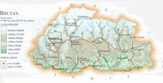
| location: South Asia, in the Eastern Himalayas |
| time zone: +6 UT |
| surface (land) area: 47000 sq.km = 18147 sq.mi //; - area incl. inland waters: sq.km = sq.mi |
| geographical position in extreme co-ordinates: North: 28° N / South: 27° N / East: 92° E / West: 88° E |
| borders (land): China, India |
| borders (coastline): none |
| climate: dependent by altitude ranging from tropical to alpine |
| Government |
| independent since: 1865; 1910-03-24 |
| type of government: monarchy |
| capital: Thimpu |
| administrative division: dzongkhag [districts]: 20 |
| Population |
| population according to the latest census: a reliable census has never been taken place |
| total population according to the estimate of midyear 2000: ca 805,000 [WB] // ; or: 2005,222 [CIA]; 2001: 699,000 - 2141,000 [CA] |
| population density: 33 - 113 per sq.km = 85 - 292 per sq.mi |
| population growth: 2,4% //; - doubling time: 29 years |
| birth rate: 36 - 38 per 1000 |
| death rate: 14 - 16 per 1000 |
| fertility rate: 6 children per female |
| maternal mortality: 1710 per 100,000 |
| infant mortality (in the first year of life): 94 - 127 per 1000 |
| infant mortality (from 1st - 4th year of life): 74 - 114 per 1000 |
| life expectancy: 52 years [FW: 2002: 63] (male: 53; female: 52) |
| age breakdown: 0-14 years: 40% //; - 15-59 years: 54% //; - 60+ years: 6% |
| urbanisation: 5 - 7% //; - urbanisation growth: 4,5% |
| percentage of urban population in the greatest city: % |
| Ethnic composition, language, religion |
| ethnic groups: Bhote (Drukpa, Dzongkha) 60%, Nepalese (Nepali) 30%, Assamese |
| languages: Tibetan (Dzongkha) and Nepalese dialects |
| religious affiliation: Mahayana Buddhist 70% - 75%; Hindu 20 - 24%, other ca 6% |
| Health |
| daily food intake: calories per capita |
| population with access to safe water: 64% |
| people per physician: 6250 - 13110 |
| people per hospital bed: |
| Education, literacy |
| school enrolment: primary education 6-11 years: % |
| school enrolment: secondary education: % |
| school enrolment: tertiary education 20-24 years: % |
| adult literacy: 18% (male: 31%; female: 9%) [later total figure found: 42-47% (FW 2000: 38% / m: 61% ; f: 34%) ] |
| Economy and infrastructure |
| Economy and trade |
| currency: Ngultrum (NU) = 100 che(l)trum |
| annual inflation rate: 10% [FW 2002: 2% |
| population below poverty line: % |
| Gross Domestic Product: USD 163 per capita |
| GNI USD 590 per capita //; - [ppp: 1440] |
| GDP growth: 3,4% |
| income: USD 180 per capita |
| import: USD 128 per capita //; - export: USD 67 per capita |
| trade: USD per capita //; - or 74% of GDP |
| trade partners: IN |
| human development index: 0,477 //; - position of the country in the world no.: 130 |
| female labour force: 40% |
| unemployment: % |
| tourism: 0,02 million |
| Economic activities in agriculture, fisheries, industry, mining, services, energy |
| land use: arable land: 3% //; - grass land: 6% //; - wooded area: 56% //; - arid land and desert: % |
| agriculture: labour force: 93% [FW 2000: 94%] //; - part of agriculture in GDP: 43% [FW 2002: 34%] |
| agricultural products: fruit and spices, timber, rice, corn, citrus fruits |
| livestock (1000s): asses: / cattle: 355-435 / goats: 42 / horses: 30 / pigs: 41-75 / poultry: 231-310 / sheep: 59 |
| fish catch: 330 metric tonnes |
| industry: labour force: 3% //; - part of industry in GDP: 27% [FW 2002: 37%] |
| industrial products: chemical products, cement, wood board products, distillery products |
| mining products: hydroelectricity, limestone, dolomite, gypsum, talc, slate |
| CO2 emission per capita: 0,5 |
| services: labour force: 5% //; - part of services in GDP: 30% [FW 2002: 29%] |
| energy use (kg per capita): 2816 |
| electricity use (per capita): |
| annual water use (per capita): |
| Traffic, communication |
| road network: 3285 km //; - of which paved: 79% [2240] //; - of which are motorways: 0 km |
| vehicles: 5 per 1000 // international license plate: BT |
| railways: 0 km //; - railways passenger/km: - |
| navigable inland waterways: 0 km |
| ownership telephone: 6 - 26 per 1000 // international dialling code: +975 |
| ownership radio receivers: 28 per 1000 |
| ownership tv-sets: 19 per 1000 |
| newspaper circulation: per 1000 |
| persons per post office: 7990 |
| personal computers: 5 per 1000 |
| Some physical landmarks |
| mountains: Kula Kangri 7554 m, Chomo Lhari 7314 |
| lowest point: at the Southern border with India, possibly where the Dangme river leaves the country |
| lakes (natural): none |
| lakes (artificial reservoirs): none |
| lakes (deepest): none |
| rivers: Torsa, Wang, Sankosh, Mangde, Dangme, Kuru |
| canals: none |
| waterfalls: unknown |
| caves: longest system: unknown / deepest: |
| islands: none |
| deserts: none |
| other natural features: |
| Additional remarks, especially on the statistical information |
| other important features: |
| apart from physical landmarks most of the above figures are changeable, in most cases they date from the 1990's |
| primary sources used for the general information: |
| BB CA DK EV FW PW WA WB WR, and some - local national or international - statistical yearbooks |
| particulars concerning population data: |
| all available and consulted sources state great differences in estimates of population figures |
 To the page containing the population growth statistics of the country
 To the page containing the historical population growth statistics of the provinces
 To the page containing urban historical population statistics
 Back to the homepage of this website: POPULATION STATISTICS
Internet website:Latest modification of this page on 2004-12-21 by Jan Lahmeyer
© "Populstat" website: Jan Lahmeyer