All countries of the world listed from A-Z:

or choose from the countries per continent below:


 |  |  |  |  |  |
 | GRENADAgeneral data of the country |
| General useful information |
| Note: some data are of constant value, while other are due to changes, fluctuations etc. |
| Nation and population |
| official name (short form): Grenada |
| country code ISO: GD //; - FIPS: GJ |
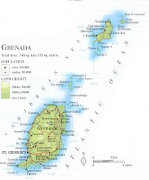
| location: Central America, West Indies, Caribbean, Lesser Antilles |
| time zone: -4 UT |
| surface (land) area: 344 sq.km = 133 sq.mi //; - area incl. inland waters: sq.km = sq.mi |
| geographical position in extreme co-ordinates: North/South: 12° N / East/West: 62° W |
| borders (land): none |
| borders (coastline): Atlantic Ocean, Caribbean Sea |
| climate: tropical, Caribbean maritime |
| Government |
| independent since: 1974-02-07 |
| type of government: republic |
| capital: Saint George's |
| administrative division: local council (8) |
| Population |
| population according to the latest census (1991): 95,597 |
| total population according to the estimate of midyear 2000: 89,018; or: 98,000; 2001: 94,000 |
| population density: 275 per sq.km = 710 per sq.mi |
| population growth: 0,4% //; - doubling time: 29 years |
| birth rate: 23 - 29 per 1000 |
| death rate: 6 - 8 per 1000 |
| fertility rate: 3 children per female |
| maternal mortality: per 100,000 |
| infant mortality (1-4 years): 15 per 1000 |
| life expectancy: 65 - 72 years (male: 63 - 69; female: 66 - 74) |
| age breakdown: 0-14 years: 38% //; - 15-59 years: 51% //; - 60+ years: 11% |
| urbanisation: 37% //; - urbanisation growth: % |
| percentage of urban population in the greatest city: % |
| Ethnic composition, language, religion |
| ethnic groups: black 85%; mixed 11%; Indo-Pakistani 3%; white 0,7%; other 0,4% |
| languages: English (official); French patois |
| religious affiliation: Roman Catholic 53%; Anglican 14%; other 33% |
| Health |
| daily food intake: calories per capita |
| population with access to safe water: 85% |
| people per physician: 1600 |
| people per hospital bed: |
| Education, literacy |
| school enrolment: primary education 6-11 years: 98% |
| school enrolment: secondary education: 16% |
| school enrolment: tertiary education 20-24 years: 5% |
| adult literacy: 85 - 90% (male: %; female: %) |
| Economy and infrastructure |
| Economy and trade |
| currency: East Caribbean dollar = 100 cents |
| annual inflation rate: 2,5% |
| population below poverty line: % |
| Gross Domestic Product: USD 2980 per capita |
| GNI USD 3770 per capita //; - [ppp: 6960] |
| GDP growth: 3% |
| income: USD 2180 per capita |
| import: USD 117 per capita //; - export: USD 20 per capita |
| trade: USD 1342 per capita //; - or 68% of GDP |
| trade partners: GB NL DE TT US JP |
| human development index: 0,795 //; - position of the country in the world no.: ca 50 |
| female labour force: 49% |
| unemployment: % |
| tourism: 0,13 million |
| Economic activities in agriculture, fisheries, industry, mining, services, energy |
| land use: arable land: 38% //; - grass land: 3% //; - wooded area: 9 - 15% //; - arid land and desert: % |
| agriculture: labour force: 14% //; - part of agriculture in GDP: 21% |
| agricultural products: nutmeg (2nd world producer), bananas, coconuts, sugarcane, cocoa, mace, timber |
| livestock (1000s): cattle: 4,4 / goats: 7-11 / pigs: 5,3 / poultry: 220-280 / sheep: 13 |
| fish catch: metric tonnes |
| industry: labour force: 9% //; - part of industry in GDP: 19% |
| industrial products: some food processing, beverages, textiles |
| mining products: none |
| CO2 emission per capita: 1,9 |
| services: labour force: 77% //; - part of services in GDP: 60% |
| energy use (kg per capita): 293 |
| electricity use (per capita): |
| annual water use (per capita): |
| Traffic, communication |
| road network: 1127 km //; - of which paved: 51% //; - of which are motorways: 0 km |
| vehicles: 122 per 1000 |
| railways: 0 km //; - railways passenger/km: - |
| navigable inland waterways: 0 km |
| ownership telephone: 255 - 315 per 1000 |
| ownership radio receivers: 489 - 615 per 1000 |
| ownership tv-sets: 158 - 325 per 1000 |
| newspaper circulation: 45 per 1000 |
| persons per post office: 1680 |
| personal computers: 127 per 1000 |
| Some physical landmarks |
| mountains: Mt. Saint Catherine 840 m, South East Mountain 716, Mt. Sinai 703, Mt. Granby 683 |
| lowest point: sea level |
| lakes (natural): a few tiny lakes: Grand Étang, Lake Antoine, Lavera Pond |
| lakes (artificial reservoirs): unknown |
| lakes (deepest): unknown |
| rivers: a few small rivers that drain the mountain slopes, among them: Great River |
| canals: none, or: unknown |
| waterfalls: Annadale Falls |
| caves: longest system: unknown / deepest: |
| islands: besides Grenada and Carriacou there are another 20 smaller islands |
| deserts: none |
| other natural features: |
| Additional remarks, especially on the statistical information |
| other important features: |
| apart from physical landmarks most of the above figures are changeable, in most cases they date from the 1990's |
| if there is a range between the figures, the differences are due to the use of several sources |
| primary sources used for the general information: |
| BB CA EV PW WA WB WR, and some national statistical yearbooks |
| particulars concerning population data: |
 To the page containing the population growth statistics of the country
 To the page containing the historical population growth statistics of the provinces
 To the page containing urban historical population statistics
 Back to the homepage of this website: POPULATION STATISTICS
Internet website:Latest modification of this page on 2004-02-15 by Jan Lahmeyer
© "populstat" site: Jan Lahmeyer