All countries of the world listed from A-Z:

or choose from the countries per continent below:


 |  |  |  |  |  |
 | CAYMAN ISLANDSgeneral data of the country |
| General useful information |
| Note: some data are of constant value, while other are due to changes, fluctuations etc. |
| Nation and population |
| official name (short form): The Cayman Islands |
| country code ISO: KY //; - FIPS: CJ |
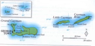
| location: Caribbean Sea, 300 km NW of Jamaica |
| time zone: -5 UT |
| surface (land) area: 259 sq.km = 100 sq.mi //; - area incl. inland waters: sq.km = sq.mi |
| geographical position in extreme co-ordinates: North/South: 19° N / East/West: 80° W |
| borders (land): none |
| borders (coastline): Caribbean Sea |
| climate: tropical Caribbean |
| Government |
| independent since: 1959-07-04 ; 1962 |
| type of government: crown colony of the United Kingdom |
| capital: Georgetown |
| administrative division: none |
| Population |
| population according to the latest census (1989): 25,355 |
| total population according to the estimate of midyear 2000: 34,763; or: 35,000 //; 2001: 35,527, or: 39,000 |
| population density: 137 per sq.km = 355 per sq.mi |
| population growth: 4,5% //; - doubling time: ca 25 years |
| birth rate: 14 - 15 per 1000 |
| death rate: 4 - 5 per 1000 |
| fertility rate: 1 child per female |
| maternal mortality: per 100,000 |
| infant mortality (in the first year of life): per 1000 |
| infant mortality (from 1st - 4th year of life): 8 per 1000 |
| life expectancy: 77 years (male: 74-75; female: 79-80) |
| age breakdown: 0-14 years: % //; - 15-59 years: % //; - 60+ years: % |
| urbanisation: 100% //; - urbanisation growth: % |
| percentage of urban population in the greatest city: % |
| Ethnic composition, language, religion |
| ethnic groups: Mixed 40%; White 20%; Black 20% |
| languages: English |
| religious affiliation: Christian |
| Health |
| daily food intake: calories per capita |
| population with access to safe water: % |
| people per physician: 700 |
| people per hospital bed: |
| Education, literacy |
| school enrolment: primary education 6-11 years: % |
| school enrolment: secondary education: % |
| school enrolment: tertiary education 20-24 years: % |
| adult literacy: 98% (male: %; female: %) |
| Economy and infrastructure |
| Economy and trade |
| currency: Caymanian dollar = 100 cents |
| annual inflation rate: % |
| population below poverty line: % |
| Gross Domestic Product: USD per capita |
| GNI USD per capita //; - [ppp: ] |
| GDP growth: % |
| income: USD 13670 per capita |
| import: USD per capita //; - export: USD per capita |
| trade: USD 5000 per capita //; - or % of GDP |
| trade partners: US GB |
| human development index: //; - position of the country in the world no.: |
| female labour force: % |
| unemployment: % |
| tourism: 0,4 million |
| Economic activities in agriculture, fisheries, industry, mining, services, energy |
| land use: arable land: % //; - grass land: 8% //; - wooded area: 23% //; - arid land and desert: % |
| agriculture: labour force: % //; - part of agriculture in GDP: % |
| agricultural products: lobsters, mussels |
| livestock (1000s; or: million): asses: / buffaloes: / camels: / cattle: / goats: / horses: / mules: / pigs: / poultry: / sheep: |
| fish catch: 125 metric tonnes |
| industry: labour force: % //; - part of industry in GDP: % |
| industrial products: banking is the main activity, if that's called an industry |
| mining products: none |
| CO2 emission per capita: |
| services: labour force: % //; - part of services in GDP: % |
| energy use (kg per capita): |
| electricity use (per capita): |
| annual water use (per capita): |
| Traffic, communication |
| road network: 120 km //; - of which paved: % //; - of which are motorways: 0 km |
| vehicles: per 1000 // international license plate: |
| railways: 0 km //; - railways passenger/km: - |
| navigable inland waterways: 0 km |
| ownership telephone: 642 ; 762 ; 1072 per 1000 [several sources state different figures] // international dialling code: +345 |
| ownership radio receivers: per 1000 |
| ownership tv-sets: per 1000 |
| newspaper circulation: per 1000 |
| persons per post office: |
| personal computers: per 1000 |
| Some physical landmarks |
| mountains: elevation up to 13 m; but no names of hills are found in atlantes or on maps at the disposal of the compiler |
| lowest point: sea level |
| lakes (natural): Malportas Pond |
| lakes (artificial reservoirs): |
| lakes (deepest): unknown |
| rivers: none |
| canals: none |
| waterfalls: none |
| caves: longest system: none / deepest: |
| islands: see the separate file of the administrative division |
| deserts: none |
| other natural features: |
| Additional remarks, especially on the statistical information |
| other important features: |
| apart from physical landmarks most of the above figures are changeable, in most cases they date from the 1990's |
| An archipelago of low-lying rocky islands surrounded by coral reefs |
| primary sources used for the general information: |
| BB CA DK EV FW PW WA WB WR, and some - local national or international - statistical yearbooks |
| particulars concerning population data: |
 To the page containing the population growth statistics of the country
 To the page containing the historical population growth statistics of the provinces
 To the page containing urban historical population statistics
 Back to the homepage of this website: POPULATION STATISTICS
Latest modification of this page on 2004.12.24 by Jan Lahmeyer
© "Populstat" website: Jan Lahmeyer