All countries of the world listed from A-Z:

or choose from the countries per continent below:


 |  |  |  |  |  |
 | CHRISTMAS ISLANDgeneral data of the country |
| General useful information |
| Note: some data are of constant value, while other are due to changes, fluctuations etc. |
| Nation and population |
| official name (short form): Christmas Island |
| country code ISO: CX [?] //; - FIPS: KT |
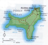
| location: Indian Ocean, 380 km ssw of the island Java {Indonesia} |
| time zone: +7 UT |
| surface (land) area: 135 sq.km = 52 sq.mi //; - area incl. inland waters: 135 sq.km = 52 sq.mi |
| geographical position in extreme co-ordinates: North/South: 10° S / East/West: 106° E |
| borders (land): none |
| borders (coastline): Indian Ocean |
| climate: tropical oceanic |
| Government |
| independent since: not yet |
| type of government: dependent territory of Australia since 1958-10-01 |
| capital: Flying Fish Cove (not official, but it's the only settlement on the island, shown on most maps) |
| administrative division: none |
| Population |
| population according to the latest census 2001: 1,508 |
| total population according to the estimate of midyear 2000: 2,564 // -; 2002: 1,506 [however, source DK states: 433] |
| population density: 19 per sq.km = 40 per sq.mi |
| population growth: % //; - doubling time: years |
| birth rate: 16 per 1000 |
| death rate: 1 per 1000 |
| fertility rate: children per female |
| maternal mortality: per 100,000 |
| infant mortality (in the first year of life): per 1000 |
| infant mortality (from 1st - 4th year of life): per 1000 |
| life expectancy: years (male: ; female: ) |
| age breakdown: 0-14 years: % //; - 15-59 years: % //; - 60+ years: % |
| urbanisation: 0% [there are no "urban" settlements] //; - urbanisation growth: -% |
| percentage of urban population in the greatest city: -% |
| Ethnic composition, language, religion |
| ethnic groups: Chinese 60% [FW 1996: 70%] ; Malay 25% [FW: 10%] ; Europeans 12% [FW: 20%] ; other 3% |
| languages: Chinese, Malay, English |
| religious affiliation: Buddhist 55%; Christian 15%; Muslim 10% |
| Health |
| daily food intake: calories per capita |
| population with access to safe water: % |
| people per physician: |
| people per hospital bed: |
| Education, literacy |
| school enrolment: primary education 6-11 years: 100% |
| school enrolment: secondary education: % |
| school enrolment: tertiary education 20-24 years: % |
| adult literacy: % (male: %; female: %) |
| Economy and infrastructure |
| Economy and trade |
| currency: Australian dollar = 100 cents |
| annual inflation rate: % |
| population below poverty line: % |
| Gross Domestic Product: USD per capita |
| GNI USD per capita //; - [ppp: ] |
| GDP growth: % |
| income: USD per capita |
| import: USD per capita //; - export: USD per capita |
| trade: USD per capita //; - or % of GDP |
| trade partners: AU NZ |
| human development index: //; - position of the country in the world no.: |
| female labour force: % |
| unemployment: % |
| tourism: million |
| Economic activities in agriculture, fisheries, industry, mining, services, energy |
| land use: arable land: % //; - grass land: % //; - wooded area: % //; - arid land and desert: % |
| agriculture: labour force: % //; - part of agriculture in GDP: % |
| agricultural products: papayas, guavas, coconuts, limes, bananas |
| livestock (1000s; or: million): asses: / buffaloes: / camels: / cattle: / goats: / horses: / mules: / pigs: / poultry: / sheep: |
| fish catch: metric tonnes |
| industry: labour force: % //; - part of industry in GDP: % |
| industrial products: of little importance |
| mining products: phosphates |
| CO2 emission per capita: |
| services: labour force: % //; - part of services in GDP: % |
| energy use (kg per capita): |
| electricity use (per capita): |
| annual water use (per capita): |
| Traffic, communication |
| road network: km //; - of which paved: % //; - of which are motorways: km |
| vehicles: ? per 1000 // international license plate: AUS (?) |
| railways: one line of ca 20 km //; - railways passenger/km: - |
| navigable inland waterways: 0 km |
| ownership telephone: per 1000 // international dialling code: |
| ownership radio receivers: 400 per 1000 |
| ownership tv-sets: 240 per 1000 |
| newspaper circulation: per 1000 |
| persons per post office: |
| personal computers: per 1000 |
| Some physical landmarks |
| mountains: Murray Hill 361 m, Ross Hill 319, Headridge Hill 288 |
| lowest point: sea level |
| lakes (natural): none |
| lakes (artificial reservoirs): none |
| lakes (deepest): unknown |
| rivers: none |
| canals: none |
| waterfalls: none |
| caves: longest system: unknown / deepest: none |
| islands: this country only consists of one island |
| deserts: none |
| other natural features: |
| Additional remarks, especially on the statistical information |
| other important features: |
| apart from physical landmarks most of the above figures are changeable, in most cases they date from the 1990's |
| discovered on Christmas Day 1643 /;/ the main town of "Flying Fish Cove" is also known as "The Settlement" |
| primary sources used for the general information: |
| BB CA DK EV FW PW WA WB WR, and some - local national or international - statistical yearbooks |
| particulars concerning population data: |
 To the page containing the population growth statistics of the country
 To the page containing some statistics of the other Australian dependent territories
 Back to the homepage of this website: POPULATION STATISTICS
© "Populstat" website: Jan Lahmeyer