All countries of the world listed from A-Z:

or choose from the countries per continent below:


 |  |  |  |  |  |
 | ZIMBABWEgeneral data of the country |
| General useful information |
| Note: some data are of constant value, while other are due to changes, fluctuations etc. |
| Nation and population |
| official name (short form): Zimbabwe |
| country code ISO: ZW //; - FIPS: ZI |
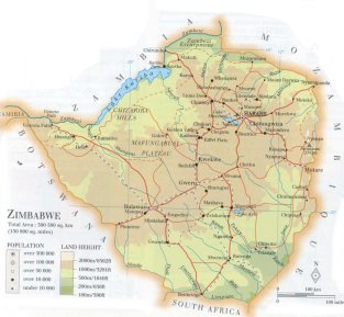
| location: Southern Africa |
| time zone: +2 UT |
| surface (land) area: 390757 sq.km = 150872 sq.mi //; - area incl. inland waters: sq.km = sq.mi |
| geographical position in extreme co-ordinates: North: 15° S / South: 22° S / East: 33° E / West: 25° E |
| borders (land): Zambia, Mozambique, South Africa, Botswana, Namibia |
| borders (coastline): none |
| climate: tropical, temperated by altitude |
| Government |
| independent since: 1980-04-18 |
| type of government: republic |
| capital: Harare |
| administrative division: province (8) + city district (2) |
| Population |
| population according to the latest census (1992): 10401,767; or: 10412,548 |
| total population according to the estimate of midyear 2000: 11342,521; or: 12627,000 |
| population density: 29 per sq.km = 75 per sq.mi |
| population growth: 3% //; - doubling time: 50 years |
| birth rate: 25 - 32 per 1000 |
| death rate: 18 - 23 per 1000 |
| fertility rate: 4 - 5 children per female |
| maternal mortality: 480 per 100,000 |
| infant mortality (1-4 years): 73 per 1000 |
| life expectancy: 38 - 40 [60] years (male: 39 [58]; female: 36 [62]) between square brackets is possibly only for white population |
| age breakdown: 0-14 years: 45% //; - 15-59 years: 51% //; - 60+ years: 4% |
| urbanisation: 35% //; - urbanisation growth: 6% |
| percentage of urban population in the greatest city: 50% |
| Ethnic composition, language, religion |
| ethnic groups: Shona 71%; Ndebele 16%; European 2% |
| languages: English (official); Shona, SiNdebele |
| religious affiliation: Animist/traditional beliefs 41%; Protestant 35%; African indigenous 14%; Roman Catholic 8% |
| Health |
| daily food intake: 2153 calories per capita |
| population with access to safe water: 77 - 85% |
| people per physician: 6904 |
| people per hospital bed: 501 |
| Education, literacy |
| school enrolment: primary education 6-11 years: 100% |
| school enrolment: secondary education: 52% |
| school enrolment: tertiary education 20-24 years: 6% |
| adult literacy: 85% (male: 90%; female: 80%) [later toatl figure found: 93%] |
| Economy and infrastructure |
| Economy and trade |
| currency: Zimbabwe dollar = 100 cents |
| annual inflation rate: 26% |
| population below poverty line: 25% |
| Gross Domestic Product: USD 490 per capita |
| GNI USD 460 per capita //; - [ppp: 2550] |
| GDP growth: 0,4% |
| income: USD 620 per capita |
| import: USD 2726 per capita //; - export: USD 1895 per capita |
| trade: USD 381 per capita //; - or 45% of GDP |
| trade partners: ZA GB US DE |
| human development index: 0,554 //; - position of the country in the world no.: 117 |
| female labour force: 45% |
| unemployment: 40% |
| tourism: 1,9 million |
| Economic activities in agriculture, fisheries, industry, mining, services, energy |
| land use: arable land: 7% //; - grass land: 13% //; - wooded area: 49% //; - arid land and desert: % |
| agriculture: labour force: 65% //; - part of agriculture in GDP: 20% |
| agricultural products: sugarcane, maize, tobacco leaves, vegetables, seed cotton, wheat, soybeans, cotton |
| livestock (million): asses: 0,1 / cattle: 5,6 / goats: 2,8 / pigs: 0,3 / poultry: 16 / sheep: 0,5 |
| fish catch: 12406 - 18241 metric tonnes |
| industry: labour force: 6% //; - part of industry in GDP: 32% |
| industrial products: chemicals, textiles, clothing, food processing, transport equipment, steel |
| mining products: gold, coal, asbestos, nickel, copper, silver, iron, emeralds, lithium, chromium |
| CO2 emission per capita: 1,2 |
| services: labour force: 30% //; - part of services in GDP: 48% |
| energy use (kg per capita): 821 |
| electricity use (per capita): 894 |
| annual water use (per capita): 136 |
| Traffic, communication |
| road network: 85237, or 91810 km //; - of which paved: 18, or 47% //; - of which are motorways: 0 km |
| vehicles: 29 per 1000 |
| railways: 2759 km //; - railways passenger/km: 546 |
| navigable inland waterways: 0 km |
| ownership telephone: 14 - 21 per 1000 |
| ownership radio receivers: 93 - 113 per 1000 |
| ownership tv-sets: 12 - 30 per 1000 |
| newspaper circulation: 17 per 1000 |
| persons per post office: 39900 |
| personal computers: 12 - 13 per 1000 |
| Some physical landmarks |
| mountains: Inyangani 2592 m, nameless peak? 2286, Nyangui 2230, nameless peak? 2211 |
| lowest point: possibly in the Southeastern tip of the country |
| lakes (natural): Lake Manyamé, Lake Kyle |
| lakes (artificial reservoirs): Lake Kariba |
| lakes (deepest): unknown |
| rivers: Zambezi, Shangani, Sanyati, Runde, Save |
| canals: none, or unknown |
| waterfalls: Victoria 104,5 m |
| caves: longest system: none, or unknown / deepest: |
| islands: none |
| deserts: none |
| other natural features: |
| Additional remarks, especially on the statistical information |
| other important features: |
| apart from physical landmarks most of the above figures are changeable, in most cases they date from the 1990's |
| primary sources used for the general information: |
| BB CA EV PW WA WB WR, and some national statistical yearbooks |
| particulars concerning population data: |
 To the page containing the population growth statistics of the country
 To the page containing the historical population growth statistics of the provinces
 To the page containing urban historical population statistics
 Back to the homepage of this website: POPULATION STATISTICS
Internet website:Latest modification of this page on 2004-03-15 by Jan Lahmeyer
© "populstat" site: Jan Lahmeyer