All countries of the world listed from A-Z:

or choose from the countries per continent below:


 |  |  |  |  |  |
 | WESTERN SAHARAgeneral data of the country |
| General useful information |
| Note: some data are of constant value, while other are due to changes, fluctuations etc. |
| Nation and population |
| official name (short form): Sahara occidental |
| country code ISO: EH //; - FIPS: WI |
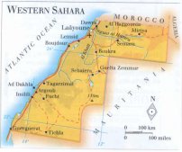
| location: Northwest Sahara |
| time zone: +0 UT |
| surface (land) area: 252120 sq.km = 97344 sq.mi //; - area incl. inland waters: sq.km = sq.mi |
| geographical position in extreme co-ordinates: North: 27° N / South: 21° N / East: 9° W / West: 17° W |
| borders (land): Morocco, Algeria, Mauritania |
| borders (coastline): Atlantic Ocean |
| climate: subtropical arid |
| Government |
| independent since: 1976-02-27 |
| type of government: annexed by Morocco in 1979 |
| capital: Laayoune [El Aaiún] |
| administrative division: wilaya [provinces] (4) |
| Population |
| population according to the latest census (1994): 252,146 |
| total population according to the estimate of midyear 2001: 250,559; or: 306,000 |
| population density: 1 per sq.km = 2.6 per sq.mi |
| population growth: 4% //; - doubling time: ca 20 years |
| birth rate: 47 per 1000 |
| death rate: 18,5 per 1000 |
| fertility rate: 7 children per female |
| maternal mortality: per 100,000 |
| infant mortality (1-4 years): 149 per 1000 |
| life expectancy: 46,5 years (male: 45,3; female: 47,6) |
| age breakdown: 0-14 years: 42% //; - 15-59 years: 45% //; - 60+ years: 3% |
| urbanisation: 91% //; - urbanisation growth: % |
| percentage of urban population in the greatest city: 65% |
| Ethnic composition, language, religion |
| ethnic groups: Sahrawi |
| languages: Arabic (Hassaniyah), French, Spanish |
| religious affiliation: Sunnî Muslim >78%; Roman Catholic <22% |
| Health |
| daily food intake: calories per capita |
| population with access to safe water: % |
| people per physician: 2275 |
| people per hospital bed: |
| Education, literacy |
| school enrolment: primary education 6-11 years: % |
| school enrolment: secondary education: % |
| school enrolment: tertiary education 20-24 years: % |
| adult literacy: % (male: %; female: %) |
| Economy and infrastructure |
| Economy and trade |
| currency: Moroccan dirham |
| annual inflation rate: % |
| population below poverty line: % |
| Gross Domestic Product: USD 300 per capita |
| GNI USD per capita //; - [ppp: ] |
| GDP growth: % |
| income: USD per capita |
| import: USD per capita //; - export: USD per capita |
| trade: USD per capita //; - or % of GDP |
| trade partners: |
| human development index: //; - position of the country in the world no.: |
| female labour force: % |
| unemployment: % |
| tourism: 0 million |
| Economic activities in agriculture, fisheries, industry, mining, services, energy |
| land use: arable land: <19% //; - grass land: 20% //; - wooded area: <1% //; - arid land and desert: ca 65% |
| agriculture: labour force: % //; - part of agriculture in GDP: <1% |
| agricultural products: grains |
| livestock (1000s): asses: / camels: / cattle: / goats: / horses: / pigs: - / poultry: / sheep: 29 |
| fish catch: metric tonnes |
| industry: labour force: % //; - part of industry in GDP: 40% |
| industrial products: of no importance |
| mining products: phosphate rock, iron ore, copper |
| CO2 emission per capita: |
| services: labour force: % //; - part of services in GDP: ca 60% |
| energy use (kg per capita): |
| electricity use (per capita): 351 |
| annual water use (per capita): |
| Traffic, communication |
| road network: 6200 km //; - of which paved: 23% //; - of which are motorways: 0 km |
| vehicles: 27 per 1000 |
| railways: 0 km //; - railways passenger/km: - |
| navigable inland waterways: 0 km |
| ownership telephone: per 1000 |
| ownership radio receivers: 137 per 1000 |
| ownership tv-sets: 17 per 1000 |
| newspaper circulation: per 1000 |
| persons per post office: |
| personal computers: per 1000 |
| Some physical landmarks |
| mountains: on maps as highest elevations: nameless peak of 823 m in the NE; and Zemmour 805 m |
| lowest point: Sebkhet Tah 55 m below sea level |
| lakes (natural): some salt lakes, like Sebkhet Aghzoumal |
| lakes (artificial reservoirs): none, or unknown |
| lakes (deepest): unknown |
| rivers (mainly dry rivers [wâdîs], like): Saguia el-Hamra, Oued el Khatt, Oued Assaq |
| canals: none, or unknown |
| waterfalls: none, or unknown |
| caves: longest system: none, or unknown / deepest: |
| islands: a few tiny ones south of Cape Barbas |
| deserts: western edge of the Sahara |
| other natural features: |
| Additional remarks, especially on the statistical information |
| other important features: |
| apart from physical landmarks most of the above figures are changeable, in most cases they date from the 1990's |
| most figures are unreliable; in some sources recent data are not stated separated from Morocco anymore |
| primary sources used for the general information: |
| BB CA EV PW WA WB WR, and some national statistical yearbooks |
| particulars concerning population data: |
 Back to the homepage of this website: POPULATION STATISTICS
Latest modification of this page on 2004-03-14 by Jan Lahmeyer
© "populstat" site: Jan Lahmeyer
-->