All countries of the world listed from A-Z:

or choose from the countries per continent below:


 |  |  |  |  |  |
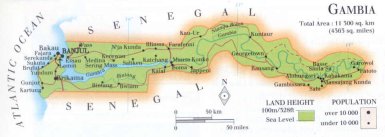 | The GAMBIAgeneral data of the country |
| General useful information |
| Note: some data are of constant value, while other are due to changes, fluctuations etc. |
| Nation and population |
| official name (short form): The Gambia |
| country code ISO: GM //; - FIPS: GA |
| location: West Africa |
| time zone: +0 UT |
| surface (land) area: 11300 sq.km = 4363 sq.mi //; - area incl. inland waters: sq.km = sq.mi |
| geographical position in extreme co-ordinates: North: 14° N / South: 13° N / East: 14° W / West: 17° W |
| borders (land): Senegal |
| borders (coastline): Atlantic Ocean |
| climate: subtropical |
| Government |
| independent since: 1965-02-18 |
| type of government: republic |
| capital: Banjul |
| administrative division: division (6) |
| Population |
| population according to the latest census (1993): 1036,145 |
| total population according to the estimate of midyear 2000: 1367,124; or: 1303,000 // - ; 2001: 1337,000 |
| population density: 118 per sq.km = 307 per sq.mi |
| population growth: 4% //; - doubling time: 29 years |
| birth rate: 42 - 45 per 1000 |
| death rate: 13 - 20 per 1000 |
| fertility rate: 7 children per female |
| maternal mortality: per 100,000 |
| infant mortality (1-4 years): 132 per 1000 |
| life expectancy: 45 - 54 years (male: 43 - 52; female: 47 - 56) [differences depend on source used] |
| age breakdown: 0-14 years: 44% //; - 15-59 years: 51% //; - 60+ years: 5% |
| urbanisation: 23 - 33% //; - urbanisation growth: % |
| percentage of urban population in the greatest city: 100% |
| Ethnic composition, language, religion |
| ethnic groups: Madinka 34%; Fula(ni) 16%; Wolof 13%; Dyolo (Yola) 9%; Serahuli 8%; Soninke 8% |
| languages: English (official); Madinka, Fula, Wolof |
| religious affiliation: Sunnî Muslim 95%; Christian 4% |
| Health |
| daily food intake: 2559 calories per capita |
| population with access to safe water: 76% |
| people per physician: 11600 |
| people per hospital bed: |
| Education, literacy |
| school enrolment: primary education 6-11 years: 75% |
| school enrolment: secondary education: 20% |
| school enrolment: tertiary education 20-24 years: 0,4% |
| adult literacy: 27% (male: 39%; female: 16%) |
| Economy and infrastructure |
| Economy and trade |
| currency: Dalasi = 100 butut |
| annual inflation rate: 4% |
| population below poverty line: 64% |
| Gross Domestic Product: USD 320 per capita |
| GNI USD 340 per capita //; - [ppp: 1620] |
| GDP growth: -0,3% |
| income: USD 360 per capita |
| import: USD 141 per capita //; - export: USD 22 per capita |
| trade: USD 298 per capita //; - or % of GDP |
| trade partners: CH FR NL BE GW GB TH ES |
| human development index: 0,398 //; - position of the country in the world no.: 149 |
| female labour force: 45% |
| unemployment: % |
| tourism: 0,1 million |
| Economic activities in agriculture, fisheries, industry, mining, services, energy |
| land use: arable land: 18% //; - grass land: 9% //; - wooded area: 16% //; - arid land and desert: % |
| agriculture: labour force: 84% //; - part of agriculture in GDP: 34% |
| agricultural products: groundnuts, paddy rice, millet, sorghum, cassava, pulses, palm oil & - kernels |
| livestock (1000s): cattle: 364 / goats: 145-270 / pigs: 14 / poultry: 740-780 / sheep: 106-195 |
| fish catch: 32258 metric tonnes |
| industry: labour force: 7% //; - part of industry in GDP: 12% |
| industrial products: some food processing, peanut processing |
| mining products: limenite, zircon, rutile, kaolin, tin |
| CO2 emission per capita: 0,2 |
| services: labour force: 9% //; - part of services in GDP: 54% |
| energy use (kg per capita): 56 |
| electricity use (per capita): |
| annual water use (per capita): 30 |
| Traffic, communication |
| road network: 2386 - 2700 km //; - of which paved: 35% //; - of which are motorways: 0 km |
| vehicles: 6 per 1000 |
| railways: 0 km //; - railways passenger/km: - |
| navigable inland waterways: 400 km |
| ownership telephone: 17 - 23 per 1000 |
| ownership radio receivers: 125 - 165 per 1000 |
| ownership tv-sets: 4 - 35 per 1000 |
| newspaper circulation: 2 per 1000 |
| persons per post office: |
| personal computers: 12 per 1000 |
| Some physical landmarks |
| mountains: highest points are hardly existing and/or of no importance, and are even not shown on maps |
| lowest point: sea level |
| lakes (natural): none |
| lakes (artificial reservoirs): none |
| lakes (deepest): none |
| rivers: Gambia |
| canals: none |
| waterfalls: none |
| caves: longest system: none / deepest: |
| islands: none |
| deserts: none |
| other natural features: |
| Additional remarks, especially on the statistical information |
| other important features: |
| apart from physical landmarks most of the above figures are changeable, in most cases they date from the 1990's |
| primary sources used for the general information: |
| BB CA EV PW WA WB WR, and some national statistical yearbooks |
| particulars concerning population data: |
 To the page containing the population growth statistics of the country
 To the page containing the historical population growth statistics of the provinces
 To the page containing urban historical population statistics
 Back to the homepage of this website: POPULATION STATISTICS
Internet website:Latest modification of this page on 2004-02-13 by Jan Lahmeyer
© "populstat" site: Jan Lahmeyer