All countries of the world listed from A-Z:

or choose from the countries per continent below:


 |  |  |  |  |  |
 | TOGOgeneral data of the country |
| General useful information |
| Note: some data are of constant value, while other are due to changes, fluctuations etc. |
| Nation and population |
| official name (short form): Togo |
| country code ISO: TG //; - FIPS: TO |
| location: West Africa |
| time zone: +0 UT |
| surface (land) area: 56785 sq.km = 21925 sq.mi //; - area incl. inland waters: sq.km = sq.mi |
| geographical position in extreme co-ordinates: North: / South: / East: / West: |
| borders (land): Ghana, Burkina Faso, Benin |
| borders (coastline): Atlantic Ocean |
| climate: tropical |
| Government |
| independent since: 1960-04-27 |
| type of government: republic |
| capital: Lomé |
| administrative division: région (5) into préfecture (21) |
| Population |
| population according to the latest census (1981): 2719,567 |
| total population according to the estimate of midyear 2000: 4527,000; or: 5018,502 /-; 2001: 4796,000; or: 5153,088 |
| population density: 80 - 88 per sq.km = 206 - 229 per sq.mi |
| population growth: 3,5% //; - doubling time: 22 years |
| birth rate: 37 - 45 per 1000 |
| death rate: 11 - 13 per 1000 |
| fertility rate: 7 children per female |
| maternal mortality: 476 per 100,000 |
| infant mortality (1-4 years): 85 per 1000 |
| life expectancy: 54 years (male: 52; female: 56) |
| age breakdown: 0-14 years: 45% //; - 15-59 years: 50% //; - 60+ years: 5% |
| urbanisation: 33% //; - urbanisation growth: 6,6% |
| percentage of urban population in the greatest city: 60% |
| Ethnic composition, language, religion |
| ethnic groups: Ewe-Adja 43,1%; Tem-Kabre 26,7%; Gurma 16,1%; Kebu-Akposo 3,8%; Ana-Ife 3,2%; Mine and 35 others |
| languages: French (official); Ewe, Kabiye, Mine, Dagomba |
| religious affiliation: traditional beliefs 50%; Roman Catholic 23%; Sunnî Muslim 15%; Protestant 12% |
| Health |
| daily food intake: 2513 calories per capita |
| population with access to safe water: 54 - 63% |
| people per physician: 12299 |
| people per hospital bed: |
| Education, literacy |
| school enrolment: primary education 6-11 years: 100% |
| school enrolment: secondary education: 32% |
| school enrolment: tertiary education 20-24 years: 2% |
| adult literacy: 52% (male: 67%; female: 37%) [later total figure found: 57%] |
| Economy and infrastructure |
| Economy and trade |
| currency: CFA franc = 100 centimes |
| annual inflation rate: 7% |
| population below poverty line: 32% |
| Gross Domestic Product: USD 320 - 1490 per capita |
| GNI USD 290 per capita //; - [ppp: 1410] |
| GDP growth: -0,4% |
| income: USD 410 per capita |
| import: USD 222 per capita //; - export: USD 162 per capita |
| trade: USD 210 per capita //; - or 73% of GDP |
| trade partners: FR ES NL CA DE IT US |
| human development index: 0,489 //; - position of the country in the world no.: 128 |
| female labour force: 40% |
| unemployment: % |
| tourism: 0,06 million |
| Economic activities in agriculture, fisheries, industry, mining, services, energy |
| land use: arable land: 12% //; - grass land: 33% //; - wooded area: 29% //; - arid land and desert: % |
| agriculture: labour force: 64% //; - part of agriculture in GDP: 33% |
| agricultural products: cassava, yams, maize, sorghum, cottonseed, millet, rice, pulses, groundnuts, coffee, cocoa, cotton |
| livestock (1000s): asses: 3 / cattle: 277 / goats: 1425 / horses: 2 / pigs: 289-850 / poultry: 6448-8500 / sheep: 740-1379 |
| fish catch: 14310 - 22924 metric tonnes |
| industry: labour force: 6% //; - part of industry in GDP: 23% |
| industrial products: mainly food processing, textiles, handicrafts |
| mining products: phosphate rock, limestone, iron, chromite, bauxite, marble |
| CO2 emission per capita: 0,2 |
| services: labour force: 29% //; - part of services in GDP: 44% |
| energy use (kg per capita): 313 |
| electricity use (per capita): |
| annual water use (per capita): 28 |
| Traffic, communication |
| road network: 7545, or 12040 km //; - of which paved: 32% //; - of which are motorways: 0 km |
| vehicles: 13 per 1000 |
| railways: 395, or 525 km //; - railways passenger/km: 14 |
| navigable inland waterways: 50 km |
| ownership telephone: 5 - 8 per 1000 |
| ownership radio receivers: 170 - 218 per 1000 |
| ownership tv-sets: 12 - 36 per 1000 |
| newspaper circulation: 2 per 1000 |
| persons per post office: 88200 |
| personal computers: 22 per 1000 |
| Some physical landmarks |
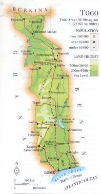
| mountains: Mont Agou (Pic Baumann) 986 m; unnamed peaks on maps: 920 & 825; Mt.Koronga 789, Mt.Kalankpa 779 |
| lowest point: sea level |
| lakes (natural): none, or unknown |
| lakes (artificial reservoirs): Retenue de Nangbéto |
| lakes (deepest): unknown |
| rivers: Mono, Ogou, Oti |
| canals: none, or unknown |
| waterfalls: none, or unknown |
| caves: longest system: none, or unknown / deepest: |
| islands: none, or unknown |
| deserts: none |
| other natural features: |
| Additional remarks, especially on the statistical information |
| other important features: |
| apart from physical landmarks most of the above figures are changeable, in most cases they date from the 1990's |
| primary sources used for the general information: |
| BB CA EV PW WA WB WR, and some national statistical yearbooks |
| particulars concerning population data: |
 To the page containing the population growth statistics of the country
 To the page containing the historical population growth statistics of the provinces
 To the page containing urban historical population statistics
 Back to the homepage of this website: POPULATION STATISTICS
Internet website:Latest modification of this page on 2004-03-10 by Jan Lahmeyer
© "populstat" site: Jan Lahmeyer